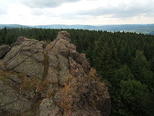
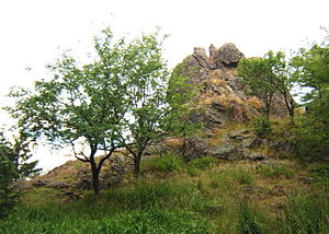
Burned stone
| Burned stone | ||
|---|---|---|
|
Main rock |
||
| height | 896.6 m above sea level NHN | |
| location | Thuringia, Germany | |
| Mountains | Thuringian Forest | |
| Dominance | 2.5 km → south summit Schützenberg ( 897.9 m ) | |
| Notch height | 79 m ↓ south of the Rädelsgraben source | |
| Coordinates | 50 ° 41 '30 " N , 10 ° 40' 5" E | |
|
|
||
| Normal way | from the Ruppberg car park | |
The burned stone is 896.6 m above sea level. NHN high mountain in the central Thuringian Forest .
location
It is located about 4 kilometers north of Zella-Mehlis and 5 km south-southwest of Oberhof .
Routes to the summit
- From the Ruppberg car park follow the Reifweg , after about 2 km a signposted path branches off to the right. From the highest point of this path, a signposted path leads to the left. This first reaches some secondary rocks with thick blueberry vegetation, then it leads to the main summit, from which the view described below is offered.
- a more scenic route leads from the Zellaer sports field ( Alte Straße ) under the ski jump. At the provisional end of the first valley, the path continues over the Lämmerröder , a very beautiful brook valley. At the edge of the dam meadow that then follows, this route branches off to the left to Heinrichsbacher Stein . From there, follow the road for a while to the northwest and after a few hundred meters turn right onto a path. At the next crossroads, follow the forest path a few meters to the left and then turn sharply right onto the path to Kaltenbrunner Stein . From there, after a few hundred meters, you get to the road described in the first route.
- Also recommended is the path from the Rondell near Oberhof via the Veilchenbrunnen . It also leads to the hut described above below the Burned Stone.

View from the main rock on Suhl
view
- south
- Ringberghaus , Großer Erleshügel and Adlersberg
- Suhl with industrial area Neuer Friedberg
- Toompea
- Zella Mehlis
- west
- The Rhön Mountains ( Kreuzberg , Heidelstein , Wasserkuppe , Geba , Dolmar )
- north
- High stone
- Ski jumping facility in Kanzlersgrund
- east

