Ruppberg
| Ruppberg | ||
|---|---|---|
|
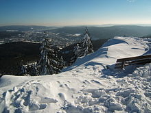
View of Ruppberghütte and the main summit |
||
| height | 866 m above sea level NHN | |
| location | near Steinbach-Hallenberg and at Zella-Mehlis ; District of Schmalkalden-Meiningen , Thuringia ( Germany ) |
|
| Mountains | Thuringian Forest | |
| Dominance | 2.2 km → Burned Stone ( 896.6 m ) | |
| Notch height | 127 m ↓ road Zella-Mehlis - Oberschönau , northeast of Mount | |
| Coordinates | 50 ° 41 '2 " N , 10 ° 38' 21" E | |
|
|
||
| Normal way | Hike from L 2691 from Ruppberg car park (approx. 30 min) | |
The Ruppberg is an 866 m above sea level. NHN high mountain in the Thuringian Forest . It is located in the urban areas of Steinbach-Hallenberg and Zella-Mehlis in the Thuringian district of Schmalkalden-Meiningen .
The mountain, whose forest-free summit lies in the east-southeast of the urban area of Steinbach-Hallenberg, is considered to be the local mountain of the south-east town of Zella-Mehlis. At the summit, the porphyry rock that makes up the mountain is clearly visible.
Geographical location
The Ruppberg rises in the central Thuringian Forest in the Thuringian Forest Nature Park . It lies between the core town of Steinbach-Hallenberg in the west-north-west, the village of Oberschönau in the north-west, the town of Oberhof in the east-north-east, the town of Zella-Mehlis in the south-east, which the mountain towers over with a volcano-like shape, and Bermbach , a district of the town of Steinbach-Hallenberg in the West.
North of the Ruppberg lies the Kanzlersgrund with the Haselbach (Hasel) called the upper reaches of the Schwarza . Beyond it rises the Hohe Stein ( 860 m ) in front of the main ridge of the mountains . The Rennsteig runs over the main ridge with the Finsterbachkopf ( 898.3 m ) . The Great Hermannsberg ( 867.4 m ) joins to the northwest, and the Gebrannte Stein ( 896.6 m ) to the east . To the southeast the landscape drops into the valley of the Lichtenau with Zella-Mehlis.
history
The Celts probably built a rampart on the Ruppberg. The remains of a moat can still be seen in the north and south below the two summit plateaus. Later, probably from the end of the 10th century to around 1200, a castle ( Ruprechtsburg Castle ) is said to have been located here, which belonged to the Lords of Nordeck. It can be assumed that the Lords of Nordeck owned a small dynastic rule. The last representative of this family ( Gebhard von Nordeck ) died in 1115 or 1120. It is said that remnants of the wall were still visible in the 18th century and small finds were made. In 1619, the Hallenberg office (until then part of the Electorate of Saxony ) was exchanged for the Hessian part of the Zent Benshausen ( Benshausen barter contract ). As a result, the Ruppberg is still on the Steinbach-Hallenberger corridor markings.
The first refuge was built in 1898 by the Ruppberg community. The present hut dates from 1958.
description
summit
A hiking trail reaches the Ruppberg at the hut of the Ruppbergverein, to the north of it there is a small side rock with a flagpole, on which the flag is always hoisted when the hut is open. In the south, the main summit rises with a summit stone on which visible prominent points are marked.
outlook
The visual destinations with a view from the Ruppberg summit include:
|
Hiking routes
- The shortest ascent leads from the Ruppberg car park on the Zella-Mehlis-Oberschönau road ( L 2691) to the summit; the last part of the trail is quite steep but equipped with steps and handrails (ascent approx. 30 minutes). In the warm season, a bus runs from the Mehlis market to the parking lot.
- From Mehliser Markt via the Friedrich Ludwig Jahn monument, the meadow at the beech fountain, Braukopfhütte (approx. 2 hours)
- From Mehliser Markt through the Ruppertstal, branch off at the barbecue area to the Waldhaus, across the meadow to the Ruppberg car park (approx. 2 hours)
- From the Zella-Mehlis sports field via the Stachelsrain , the Lämmerröder, Dammwiese, Heinrichsbacher Stein, parking lot (approx. 2 hours, 30 minutes)
- From Benshausen on the Rhön-Rennsteig hiking trail (approx. 1 hour, 30 minutes)
- From the roundabout (intersection B 247 and Rennsteig ) at Oberhof over the Schützenbergmoor , past the Veilchenbrunnen, Ruppberg car park (approx. 2 hours, 20 minutes)
- From Steinbach-Hallenberg over the Knüllfeld , Rupprasen to the summit (approx. 2 hours, 30 minutes)
More pictures
Web links
- Ruppberg (Homepage of the Ruppbergverein), on ruppberg.de
- 360-degree panorama from the Ruppberg summit (labeling of visual targets can be activated), on panorama-photo.net
Individual evidence
- ↑ a b Map services of the Federal Agency for Nature Conservation ( information )
- ↑ Steinbach unter Hallenberg, History of a Hessian-Thuringian City , therein Die Burg auf dem Ruppberg , p. 23 ff (PDF; 1.41 MB).


