Generalkogel
| Generalkogel | ||
|---|---|---|
|
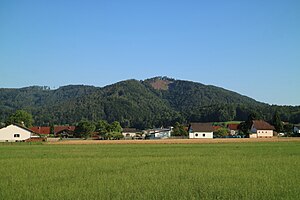
Generalkogel from the north (Hundsdorf) |
||
| height | 713 m above sea level A. | |
| location | Styria , Austria | |
| Mountains | Grazer Bergland , Lavanttal Alps | |
| Dominance | 2.5 km → Steinkogel | |
| Notch height | 73 m ↓ saddle to Straßengelberg | |
| Coordinates | 47 ° 5 '53 " N , 15 ° 19' 28" E | |
|
|
||
| rock | dolomite | |
| Age of the rock | Devon | |
| particularities | Miocene cone karst dome (heavily shaped), grave of the general | |
The Generalkogel ( Brennkogel until the 19th century ) is 713 m above sea level. A. high hill in the western part of the Grazer Bergland in the Austrian state of Styria . The elevation is not far northwest of the provincial capital Graz and is known for the grave of the general , which was redesigned in 2009.
Location and surroundings
The Generalkogel forms the western end of the Steinkogel-Frauenkogel train (also known as the Generalkogel massif), which separates the Gratkorner basin in the north from the Thaler basin in the south. The municipal boundary between Gratwein-Straßengel and Sankt Oswald bei Plankenwarth runs over the summit . The Graz city limits are located around 2 km east of the summit. The hill, which is separated from the Kugelberg in the west by Luttengraben and Rötzgraben, is clearly visible, especially from the north (Gratwein, Gratkorn and Judendorf-Straßengel). It is part of the landscape protection area of the western mountain and hill country of Graz (LSG-39) and can be reached from two sides on hiking trails.
Geology and geomorphology
The mountain consists of the Devonian Dolomites , which belong to the Graz Paleozoic . It marks the western extension of a karst plateau rich in dolines and crests , which reaches its greatest extent in the Steinkogel area (at 742 m, the highest elevation of this mountain range). Gravel from the Pannon is deposited . The Generalkogel is one of those peaks that tower over the highest level by around 30 to 40 m. These are likely to be strongly remodeled relics of a subtropical cone karst that go back to the Upper Miocene .
General's grave
The Generalkogel owes its name to a special circumstance. The grave of a former mistress of the nearby Plankenwarth Castle has been located on the summit since 1849 . Emilie Sarah Engelbronner d'Aubigny de Peché came from a Huguenot family who had been expelled from Catholic France in the 16th century . She was born in northern Germany in 1772 as the daughter of a pastor. After a well-protected childhood and a good upbringing, she emigrated to India at the beginning of the 19th century , where she founded an institute for the education of girls in Calcutta and made a certain fortune through trading in Indian goods. In addition, she met British Colonel John Peché in India, whom she married on his deathbed back in her homeland. In addition to a substantial material estate, his title passed to her and she was allowed to call herself “General” from now on.
For unknown reasons, the general ended up in Styria, where she acquired the rule and castle of Plankenwarth. From then on, the Protestant elite of Graz met here, which caused a sensation among the Catholic rural population as well as the keeping of exotic animals and an Indian slave girl. On October 27, 1849, three days before her death, the general had issued a will to be buried on the Brennkogel between Plankenwarth and Thal, after she had approved this project the year before with the Styrian state government. According to legend, she was buried with her hunting dogs. Illegal excavations were carried out in the hope of stealing valuable goods, but nothing is known of any actual finds. Death and burial are recorded in the Book of the Dead of the Heilandskirche in Graz .
Today, in the forest owned by Oberthal Castle, a wooden cross reminds of the grave next to a simple grave slab. On the occasion of the 160th anniversary of death, the memorial was redesigned in 2009 under the direction of historian Walter Brunner , in which both the grave slab and an information board were installed. Financial support came from the Rantzau family (Oberthal Castle), the communities of Thal and Sankt Oswald bei Plankenwarth and the then Deputy Governor Hermann Schützenhöfer .
photos
Literature and maps
- Freytag & Berndt Vienna, hiking map 1: 50,000, WK 133, Graz and the surrounding area - Raabklamm - Gleisdorf - Lannach - Stübing , ISBN 978-3707909357 .
- Walter Brunner : The grave of the general. On the trail of a remarkable woman from the Biedermeier period and her family . In: Miniatures on Styrian regional history and archival science , Volume 35. Ed. Josef Riegler, Graz 2006, pp. 97–116, ISBN 3-901938-17-6 .
Web links
Individual evidence
- ↑ Landscape protection area No. 29. (PDF) State of Styria , accessed on July 19, 2019 .
- ^ Herbert Paschinger: Climate-related surface shapes on the edge of the Graz Bay . In: Geographische Zeitschrift, Volume 53, Issue 2/3 (May 1965), pp. 162–170
- ^ A b Walter Brunner : The grave of the general. On the trail of a remarkable woman from the Biedermeier period and her family . In: Miniatures on Styrian regional history and archival science , Volume 35. Ed. Josef Riegler, Graz 2006, ISBN 3-901938-17-6 , pp. 97–116.


