Geyersberg (Geyer)
| Geyersberg | ||
|---|---|---|
|
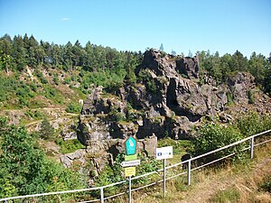
View of the Geyersberg, better known today as Geyersche Binge |
||
| height | 640.2 m above sea level NHN | |
| location | Erzgebirgskreis , Saxony ( Germany ) | |
| Mountains | Ore Mountains | |
| Coordinates | 50 ° 37 '19 " N , 12 ° 55' 45" E | |
|
|
||
The Geyersberg is 640 m above sea level. NHN high summit in the upper Ore Mountains . It is located in the southeast of the city of Geyer in the Saxon Erzgebirgskreis , Germany. The Geyersche Binge was created due to two large mining-related main quarries in 1704 and 1803 .
Location and surroundings
The Geyersberg is located in the Geyerbach valley on the south-eastern edge of the town of Geyer on the outskirts of Siebenhöfen . Today, the Geyersche Binge, known for two large incursions, is more known, which gave the mountain its current appearance. It has a depth of about 50 to 60 m and an area of about 200 × 250 m. The highest point of the mountain is to the east near the circular path around the Binge. Inside the crater of the Binge are the Small and Large Knauer. Northwest of the Geyersberg is the Geyersberg manor , first mentioned in 1510 , which is also called "Lotterhof" because of its former owner Hieronymus Lotter .
history
On the Geyersberg in the southeast of Geyer, mining was first mentioned in a document in the years 1395 to 1400. Mainly tin was mined here, but also silver , copper and other ores. In 1699 the transition to civil engineering began in the Hirtenstollen. Between 1739 and 1773, between four and ten tons of tin were produced annually. In 1767 and 1768, the “White Mine” mine produced a particularly large amount of 884 quintals of tin. In the years 1740 and 1741 there were 17 collieries, 25 stamp mills and washes and 4 tin works around Geyersberg. The mining was carried out to a depth of 106 m. Due to the hard granite rock on the Geyersberg, the technique of setting fire was mainly used. Thus, in a period of 400 years of mining activity, cavities with a diameter of up to 40 meters and a height of 35 meters were created. The many cavities and tunnels that were too close together, which were created by intensive overexploitation , ultimately became doomed for the mine under the Geyersberg. In 1704 there was the first major collapse underground , which intensified mining due to the now easier to extract fracture masses. In 1791 there was another underground quarry and in 1795 there was a first pinge break through which the lower mines were flooded. The last and most fateful break occurred on May 11, 1803, when the entire mountain collapsed and the rock did not come to rest until November of that year. It led to the cessation of civil engineering . Since then, the rock massif of the "Knauer" has protruded from the crater-shaped depression. To this day, two buried miners rest under the rock masses. After mining was resumed to a small extent from 1809, it finally came to a standstill in 1851. Between 1851 and 1929 a quarry company extracted the broken masses of the Binge, which resulted in the current extent of the Binge on Geyersberg. Since tin stone, arsenic gravel and bismuth were repeatedly found in the quarry, mining was resumed in 1907 and the Franz shaft was sunk. As early as 1913, after six years of mining, the company went bankrupt. In 1935 the binge was placed under nature protection. Between 1957 and 1960 the last mining era took place at Franz-Schacht am Geyersberg with a negative outcome. In 2011 and 2012 the new shepherd's tunnel was renovated to ensure the controlled drainage of water from the binge.
tourism
The approx. 60 meter deep collapse basin of the Geyerschen Binge can be visited on paved paths. Furthermore, the upper edge of the binge can be walked around. In the east of the mountain, near the circular route, is the highest point of the Geyersberg. Boards outside and inside the binge give information about their history. A nature trail leads around the crater of the Binge, providing information about geological conditions and rare plants and animals. In the summer months, from May to October, themed tours on mining history, the history of the binge and the collapse crater, fire-setting and old mining technologies and special tours for children are offered.
view
From the eastern edge of the Geyersberg there is a view to the southeast towards Annaberg-Buchholz . The loop around the Geyersche Binge allows views of the Binge's collapse crater from all sides.
Paths to the mountain
The Geyersberg with the Geyerschen Binge can be reached via the streets “Am Lotterhof”, “An der Binge” and the “Bingeweg”.
Web links
- Virtual guidance
- The Geyersche Binge on the website of the city of Geyer
- The Geyersche Binge (on mineralienatlas.de) , accessed on April 29, 2018
Individual evidence
- ↑ Saxony Atlas of the Free State of Saxony ( notes )
- ^ Website of Lotterhof Geyer


