
Gimbach
| Gimbach | ||
 Gimbach in Kelkheim |
||
| Data | ||
| Water code | DE : 249252 | |
| location |
Taunus
|
|
| River system | Rhine | |
| Drain over | Liederbach → Main → Rhine → North Sea | |
| source | in the Vordertaunus , west of Kelkheim 50 ° 8 ′ 10 ″ N , 8 ° 25 ′ 57 ″ E |
|
| Source height | approx. 235 m above sea level NHN | |
| muzzle | in Kelkheim in the Liederbach Coordinates: 50 ° 8 ′ 12 ″ N , 8 ° 27 ′ 16 ″ E 50 ° 8 ′ 12 ″ N , 8 ° 27 ′ 16 ″ E |
|
| Mouth height | approx. 194 m above sea level NHN | |
| Height difference | approx. 41 m | |
| Bottom slope | approx. 20 ‰ | |
| length | approx. 2.1 km | |
The Gimbach is an approximately two kilometer long right or west tributary of the Liederbach .
Surname
The name part 'Gim' is derived from the male name Ginno . The name "Gynnenbach" is mentioned for the first time in 1287. It means "to the brook of ginno".
geography
course
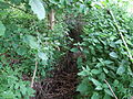
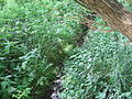
The Gimbach arises west of Kelkheim from three source streams , which arise south and north of the traditional country inn Hof Gimbach . The three source streams unite to the west of the street Zum Gimbacher Hof . The brook runs on the outskirts of Kelkheim, north of the Gimbacherweg, through fields and meadows until it reaches the city of Kelkheim on the Im Förster Grund street . There the Gimbach is reinforced from the left by a brook from the Barthelssteiner Grund nature reserve . At the corner of Gundelhardtstrasse and Altkönigstrasse, the Gimbach only continues to flow underground in the sewer system. Until 1900 it flowed openly through Friedrichstrasse, Bahnstrasse, Haingraben and Töpferstrasse to its confluence with the Liederbach.
Catchment area
The catchment area of the Gimbach lies in the Vortaunus and is drained via the Liederbach, the Main and the Rhine to the North Sea.
It borders
- in the west to that of the Schwarzbach tributary to the Main
- and in the northwest to that of the Fischbach , a tributary of the Schwarzbach.
The highest point is the 451 m above sea level. NHN high staufen .
Mixed forest dominates the upper reaches, fields and meadows on the middle and the settlement area of the town of Kelkheim on the lower reaches.
Individual evidence
- ↑ a b Topographic Map 1: 25,000 and Google Earth
- ↑ Water map service of the Hessian Ministry for the Environment, Climate Protection, Agriculture and Consumer Protection ( information )
- ↑ see The names of the waters of the Main-Taunus area by Marieluise Petran-Belschner
- ↑ a b c Gimbacher Weg ( Memento of the original from July 19, 2011 in the Internet Archive ) Info: The archive link was inserted automatically and has not yet been checked. Please check the original and archive link according to the instructions and then remove this notice.
- ↑ Topographic map 1: 25,000
- ↑ Hof Gimbach
- ↑ Großer Haingraben ( page no longer available , search in web archives ) Info: The link was automatically marked as defective. Please check the link according to the instructions and then remove this notice.
Picture gallery

Pool on the Gimbach with herons
Gimbach

Small pond on the Gimbach
Gimbach (just before the Kelkheim city area)
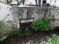
The underground Gimbach flows into the Liederbach


