Gordon River (Macquarie Harbor)
| Gordon River | ||
|
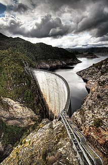
Gordon dam |
||
| Data | ||
| location | Tasmania ( Australia ) | |
| River system | Gordon River | |
| Drain over | Gordon River → Macquarie Harbor | |
| confluence | Mount King William III. ( King William Range ) 42 ° 21 ′ 22 ″ S , 146 ° 15 ′ 25 ″ E |
|
| Source height | 570 m | |
| muzzle | Southeast end of Macquarie Harbor Coordinates: 42 ° 26 ′ 8 " S , 145 ° 30 ′ 41" E 42 ° 26 ′ 8 " S , 145 ° 30 ′ 41" E |
|
| Mouth height | 0 m | |
| Height difference | 570 m | |
| Bottom slope | 3.3 ‰ | |
| length | 172 km | |
| Left tributaries | Huntley Rivulet, Adams River , Serpentine River , Albert River , Orange River , Olga River , Howards Creek, Sprent River , Cataract Creek, Abels Creek, Ghost Creek, Guy Fawkes Creek | |
| Right tributaries | Cavalier Creek, Gell River , Squirrel Creek, Reeds Creek, Boyes River , Pokana River , Holley River , Denison River , Smith River , Conellys Creek, Franklin River , Butler Rivulet, Eagle Creek, Spence River , Waterfall Creek | |
| Reservoirs flowed through | Lake Gordon | |
| Medium-sized cities | Strathgordon | |
|
Gordon River near its confluence with Macquarie Harbor |
||
The Gordon River is a river in the southwest of the Australian state of Tasmania .
geography
River course
The river arises in the northeast of Franklin Gordon Wild Rivers National Park at the confluence of Cavalier Creek (which rises in Lake Richmond) and an unnamed stream east of Mount King William III. , a mountain in the King William Range . It first flows south along the eastern flank of the Denison Range , where it was dammed at Strathgordon to Lake Gordon and Lake Pedder . Through this reservoir, which is almost completely enclosed by the national park, it takes its way to the west and turns below the dam to the north-northwest. There it flows through the Gordon Splits , a deep rock canyon that is extremely difficult to pass. After 172 km it flows into Macquarie Harbor on the west coast.
The river flows over large parts through uninhabited, barely accessible wilderness, which is part of the national park.
Tributaries with mouth heights
- Cavalier Creek - 566 m
- Gell River - 509 m
- Squirrel Creek - 506 m
- Reeds Creek - 468 m
- Huntley Rivulet - 454 m
- Boyes River - 296 m
- Pokana River - 296 m
- Adams River - 296 m
- Holley River - 296 m
- Serpentine River - 122 m
- Albert River - 64 m
- Orange River - 50 m
- Denison River - 40 m
- Smith River - 35 m
- Olga River - 29 m
- Howards Creek - 28 m
- Sprent River - 18 m
- Connelly's Creek - 18 m
- Franklin River - 17 m
- Cataract Creek - 16 m
- Butler Rivulet - 15 m
- Abels Creek - 15 m
- Ghost Creek - 11 m
- Eagle Creek - 9 m
- Spence River - 7 m
- Guy Fawkes Creek - 2 m
- Waterfall Creek - 1 m
Reservoirs flowed through
- Lake Gordon - 296 m
nature
The Gordon Splits at the confluence of the Sprent River are a narrow, approx. 100 m long breakthrough of the Gordon River through the quartzite bars of the mountains. The lower course of the river is a UNESCO World Heritage Site . Cold-temperate rainforest with a number of rare tree species can be found on its banks . The river water is of drinking water quality, even if it takes on the color of thin tea due to the high tannin content .
free time activities
From Strahan there are popular boat trips through Macquarie Harbor and up the lower reaches of the Gordon River. There are seaplane flights from Strahan, with a landing on the lower reaches of the river.

