
Al-Mafraq Governorate
| Muħāfazat Al-Mafraq Al-Mafraq Governorate
|
|
|---|---|
  |
|
| Basic data | |
| Country | Jordan |
| Capital | Mafraq |
| surface | 26,551 km² |
| Residents | 549,948 (2015) |
| density | 21 inhabitants per km² |
| ISO 3166-2 | JO-MA |
Coordinates: 32 ° 15 ' N , 37 ° 0' E
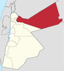
The al-Mafraq governorate ( Arabic محافظة المفرق, DMG Muḥāfaẓat al-Mafraq ) is one of the twelve governorates of Jordan. The seat of the governorate is the city of Mafraq .
history
The Jawa drinking water reservoir is located in the area, it is the oldest known dam in the world and dates from 3000 BC. Chr.
Many Roman and Byzantine sites have been found throughout the governorate, particularly churches dating back to the 3rd century AD. It is believed to be two of the oldest purpose built churches in Christianity .
During the British Mandate, Mafraq housed military facilities that are still in use today. The fifth division of the Jordanian Army is stationed in Mafraq.
geography
The province is located in the eastern part of the Kingdom of Jordan. It is the only governorate in Jordan that borders three countries: Iraq to the east, Syria to the north, and Saudi Arabia to the south. It borders the Irbid and Jerash governorates to the west and the Zarqa governorate to the south .
The climate is very dry and a large part of the area consists of deserts and desert-like landscapes.
Demographics
The population of Mafraq as of the 2004 census was 244,188, of which 30% lived in cities and 70% in the countryside. Jordanian nationals made up around 94% of the population. In the course of the Syrian civil war , a large number of people fled from the war zones in Syria to Mafraq and caused a sharp increase in the population. The Zaatari refugee camp with around 80,000 people is located in the governorate .
| year | population |
|---|---|
| 1994 (census) | 178.914 |
| 2004 (census) | 244.188 |
| 2015 (census) | 549.948 |
Individual evidence
- ↑ 2004 Census (PDF) Archived from the original on July 22, 2011.
- ^ Michael Kimmelman: Refugee Camp for Syrians in Jordan Evolves as a Do-It-Yourself City . In: The New York Times , July 4, 2013, accessed October 16, 2014
- ↑ Jordan: Governments & Cities - Population Statistics, Maps, Charts, Weather and Web Information. Retrieved May 19, 2019 .