
Grabensee (Austria)
| Grabensee | ||
|---|---|---|

|
||
| Grabensee from the south bank | ||
| GKZ | AT / DWK: 3501400, A8516824 | |
| Geographical location | Salzburger Land , Austria | |
| Tributaries | Matty | |
| Drain | Matty | |
| Location close to the shore | Perwang am Grabensee , Berndorf near Salzburg , Mattsee | |
| Data | ||
| Coordinates | 47 ° 59 '28 " N , 13 ° 5' 46" E | |
|
||
| Altitude above sea level | 503 m above sea level A. | |
| surface | at mean water 1.3 km² | |
| length | 1.9 km | |
| width | 0.8 km | |
| volume | 12,130,000 m³ | |
| Maximum depth | 14 m | |
| Middle deep | 9 m | |
|
particularities |
only outflow of the Trumer lakes |
|

The Grabensee is a lake in the Austrian province of Salzburg . It is located in the far north of the country in the Salzburg-Umgebung district on the border with Upper Austria and, as the smallest of the three Trumer Lakes, is part of the Salzburg Lake District .
Naming
The lake was first mentioned in a document in 1040 under the name Gransse . The name is derived from the old personal name Gramin , which indicates a previous landowner, administrator or holder of fishing rights. The motif for the naming is therefore the same as in the case of the Mondsee and Wolfgangsee lakes in the Salzkammergut (in its earlier name Abersee ) and possibly the nearby Wallersee . The name of Gransdorf goes back to the personal name Gramin , a hamlet on the north bank of the lake, which is likely to have been the home of this person. The linguistic form Grabensee arose over time for reasons of folk etymology .
geography
The Grabensee is about 2 km long, up to 800 m wide and has an area of around 130 hectares. The Mattig flows through the lake from south to north and flows into the Inn near Braunau . The Mattig or Grabensee is the only outflow from the three Trumer Lakes. The lake is located in a nature reserve and is a nature reserve .
The Grabensee is entirely located in the municipality of Berndorf near Salzburg . Its south or south-east bank forms the municipal boundary to Mattsee , in the southwest it borders on the municipality of Seeham for a few hundred meters . However, the closest main town to a municipality is Perwang am Grabensee in Upper Austria on the north side .
sport and freetime
The Grabensee is a nature reserve with no shipping. The mean water temperatures in summer are between 20 and 22 ° C, in hot periods temperatures up to 28 ° C are possible. In Perwang there is a natural lido, which is the only public access to the lake. This lido also includes a campsite and a tent site. Surfing and boating are prohibited for nature conservation reasons; There are some hiking trails in the area.
The scout village Zellhof is located on the southern shore of the lake .
photos
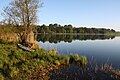
Grabensee south bank
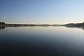
View over the Grabensee to the north

Near the confluence of the Obertrumer See

On the north bank

Aerial photo from August 17, 2011


Individual evidence
- ^ Franz Hörburger : Salzburg Place Name Book , edited by Ingo Reiffenstein and Leopold Ziller, ed. from the Salzburg Society for Regional Studies, Salzburg 1982 (without ISBN)