Greenville, Ohio
| Greenville | ||
|---|---|---|
|
Location in Ohio
|
||
| Basic data | ||
| Foundation : | 1795 | |
| State : | United States | |
| State : | Ohio | |
| County : | Darke County | |
| Coordinates : | 40 ° 6 ′ N , 84 ° 38 ′ W | |
| Time zone : | Eastern ( UTC − 5 / −4 ) | |
| Residents : | 13,294 (as of: 2000) | |
| Population density : | 852.2 inhabitants per km 2 | |
| Area : | 15.6 km 2 (about 6 mi 2 ) of which 15.6 km 2 (about 6 mi 2 ) is land |
|
| Height : | 318 m | |
| Postal code : | 45331 | |
| Area code : | +1 937 | |
| FIPS : | 39-32340 | |
| GNIS ID : | 1064762 | |
| Website : | www.cityofgreenville.org | |
| Mayor : | Michael Bowers | |
Greenville is a city in Darke County , Ohio , United States . At the 2000 census , Greenville had 13,294 residents. The city is the county seat of Darke County. A nine-day county fair is held each August, dubbed the largest of its kind in the United States. KitchenAid , a manufacturer of kitchen appliances, is based in this city.
geography
Greenville's geographic coordinates are 40 ° 6 ′ N , 84 ° 38 ′ W (40.102474, −84.627985). The place is around eleven kilometers from Darke County Airport in Versailles and 56 kilometers from James M. Cox Dayton International Airport in Vandalia .
According to the United States Census Bureau , the city has an area of 15.6 km², all of which is land.
Demographics
At the time of the United States Census 2000, Greenville was inhabited by 13,294 people. The population density was 851.2 people per km ². There were 6030 housing units at an average of 386.1 per km². The population of Greenville was 91.31% White , 0.56% Black or African American , 0.17% Native American , 0.53% Asian , 0.02% Pacific Islander , 0.44% of other races belong to and 0.97% named two or more races. 1.14% of the population declared to be Hispanic or Latino of any race.
The residents of Greenville distributed to 5649 households out of which 27.3% were living in children under 18 years. 46.5% of households were married, 11.0% had a female head of household without a husband, and 38.7% were not families. 34.4% of households were made up of individuals and someone lived in 16.9% of all households aged 65 years or older. The average household size was 2.23 and the average family size was 2.85.
The population was divided into 22.7% minors, 8.3% 18–24 year olds, 25.4% 25–44 year olds, 20.9% 45–64 year olds and 22.7% aged 65 and over or more. The average age was 40 years. For every 100 women there were 84.1 men. For every 100 women over 18, there were 78.6 men.
The median household income in Greenville was 31,791 US dollars and the median family income reached the amount of 38,699 US dollars. The median income for men was $ 33,143 compared to $ 24,875 for women. The per capita income was $ 18,830. 13.4% of the population and 10.2% of families had an income below the poverty line , including 18.8% of minors and 14.6% of those aged 65 and over.
history
Greenville was built on the site of the former fort Greene Ville, which, with an area of 55 acres , that is around 22 hectares , was the largest wooden fort that was ever built in North America. General Anthony Wayne had it built as quarters for the winter of 1793/94, in which he prepared the campaign against the Indian tribes of the northwestern territory. Wayne named the fort after his comrade, Revolutionary War general Nathanael Greene . After the Battle of Fallen Timbers , the Treaty of Greenville between the defeated tribes and the US government was signed on August 3, 1795 at this fort .
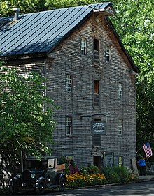
Bear's Mill , built in 1849 , whose stone millstones are hydro- powered, was entered on the National Register of Historic Places in 1977.
Greenville has a history museum that commemorates Annie Oakley and Lowell Thomas , who were both born nearby. It also houses exhibits related to Anthony Wayne and the Greenville Treaty, as well as items from the North American Indians and a racing car from the early days of the Indianapolis 500 .
Name variants
The city has a few different names:
- Fort Green Ville
- Fort Greenville
- Greeneville
- Miami's Town
- Tecumseh Point
- Tecumsehs Spring
Individual evidence
- ^ Greenville ( English ) In: Ohio History Central . Ohio Historical Society. Retrieved March 20, 2009.
- ^ Davies, Richard O. Main Street Blues: The Decline of Small-Town America. Columbus, Ohio: Ohio State University Press, 1998. p20
- ^ A b c d Doctor HF Raup Ohio Place Names Research File
- ^ US Geological Survey. Geographic Names Phase I data compilation (1976-1981). 31-Dec-1981

