Semolina
|
Semolina
Spots Aerzen
|
|
|---|---|
| Coordinates: 52 ° 0 ′ 43 ″ N , 9 ° 12 ′ 22 ″ E | |
| Height : | 140 m |
| Area : | 6.15 km² |
| Residents : | 254 (Dec. 1, 2019) |
| Population density : | 41 inhabitants / km² |
| Incorporation : | 1st January 1973 |
| Postal code : | 31855 |
| Area code : | 05154 |
|
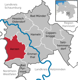
Location of Grießem in Aerzen
|
|
Griessem is a district of the borough Aerzen in the Hamelin-Pyrmont district in Lower Saxony .
location
Grießem is located in the southwest of the Hameln-Pyrmont district in the Lipper Bergland . In the south of the Weserbergland Schaumburg-Hameln nature park , it is located about 5 km southwest of the center of Aerzen, 2.5 km southwest of the Reher district , 4.3 km northwest of Bad Pyrmont and 2.7 km east-northeast of the Sonneborn district in North Rhine-Westphalia. Westphalia- lying municipality of Barntrup . To the north lies the Saalberg and to the east the Pyrmonter Berg . From southwest to northeast flowing through lobster influx Grießebach the village.
history
In Grießem, which has been predominantly Protestant since the Reformation , the Catholic Chapel of St. Mary existed in the post-war period .
On January 1, 1973, Grießem was incorporated into Aerzen.
Coat of arms
The coat of arms shows a black, half horse growing out of a blue wave flow on a golden background
The rural community of Grießem was granted permission to use the coat of arms by the Prussian State Ministry by decree of October 6, 1933.
traffic
Road traffic
Grießem is located on federal highway 1 , which runs through the northeastern village area , from which state road 426 leads towards Bad Pyrmont in the south-southeast. The next motorway is the Federal Motorway 2 with a connection at Rehren 25 km (as the crow flies ) to the north .
Rail transport
From 1897 to 1980 Griessem was a station of the raceway , to the local rail towards Hameln and Bielefeld tied. Freight traffic was given up in 1994 and the route was dismantled. The route can now be used as a cycle path (Bahnweg warehouse ).
Air traffic
The nearest airports are Hannover-Langenhagen Airport and Paderborn / Lippstadt .
literature
- Günter Graumann: In small offices and town halls - A handbook of communal self-government in the Hameln-Pyrmont district - 1945 to 1972, Volume 1 . 1st edition. Published by the district of Hameln-Pyrmont, Hameln 1988.
Individual evidence
- ^ Federal Statistical Office (ed.): Historical municipality directory for the Federal Republic of Germany. Name, border and key number changes for municipalities, counties and administrative districts from May 27, 1970 to December 31, 1982 . W. Kohlhammer GmbH, Stuttgart / Mainz 1983, ISBN 3-17-003263-1 , p. 194 .


