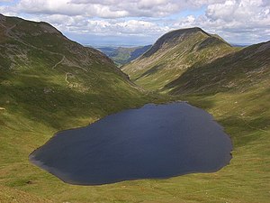
Grisedale Tarn
| Grisedale Tarn | ||
|---|---|---|

|
||
| Grisedale Tarn (facing east) | ||
| Geographical location | Lake District , Cumbria , England | |
| Drain |
Grisedale Beck → Ullswater → Eamont → Eden → Irish Sea |
|
| Data | ||
| Coordinates | 54 ° 29 ′ 57 ″ N , 3 ° 0 ′ 27 ″ W | |
|
|
||
| Altitude above sea level | 538 m | |
| length | 570 m | |
| width | 290 m | |
| Maximum depth | 34 m | |
|
particularities |
Legendary repository of King Dunmail's crown |
|
The Grisedale Tarn (not to be confused with the Grizedale Tarn in the Grizedale Forest ) is a mountain lake in the Lake District , Cumbria , England . The Tarn lies between Dollywagon Pike in the north and Fairfield in the south. The lake is 538 meters above sea level and approximately 34 meters deep. The Grisedale Beck is the outflow of the Grisedale Tarn.
Brown trout , eel and perch live in the lake .
history
According to legend, King Dunmail's crown lies in this lake.
At the outflow of the lake, the Brother's Parting Stone marks the place where William Wordsworth and his brother John saw each other for the last time, before the latter sank in 1805 as captain of the ship Earl of Abergavenny .
See also
photos
Web links
Individual evidence
- ^ Don Blair: Exploring Lakeland Tarns: Lakeland Manor Press (2003): ISBN 0-9543-9041-5 .
- ↑ a b c Archive link ( Memento of the original dated December 31, 2013 in the Internet Archive ) Info: The archive link was inserted automatically and has not yet been checked. Please check the original and archive link according to the instructions and then remove this notice.


