Great horse mountain
| Great horse mountain | ||
|---|---|---|
|
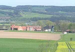
View over Wilhelmsglücksbrunn to the small and large horse mountain |
||
| height | 406.1 m above sea level NHN | |
| location | Thuringia , Germany | |
| Coordinates | 51 ° 4 '18 " N , 10 ° 13' 5" E | |
|
|
||
| rock | Shell limestone | |
The Great Horse Mountain is now a partially wooded mountain and is the highest elevation in the area of Creuzburg in the Wartburg district . It is part of the Eichsfeld-Hainich-Werratal Nature Park . The mountain plateau has a summit height of 406.1 m above sea level. NHN and was extensively cleared in the Middle Ages, field terraces are still visible in the area. The wooded hillside also belongs to the ridge
At the south-western tip of the mountain there is an open pasture area with a panoramic view of the Werra Valley , the north-western Thuringian Forest with the Wartburg and the Werra Valley Bridge near Hörschel.
The medieval Landwehr "Lampertsgraben" runs along the Großer Pferdeberg. It blocked the way into the Schnellmannshausen valley , to Treffurt and Scherbda . On the upstream Spindelskoppe and on the neighboring Stadtberg , two guard posts of this fortification with visual contact with Creuzburg Castle and Normannstein Castle are known.
The Werraburgensteig leads across the Großer Pferdeberg as a hiking trail to the neighboring town of Treffurt, to Heldrastein and into the Unstrut-Hainich district .
Individual evidence
- ↑ a b c Map services of the Federal Agency for Nature Conservation ( information )
- ↑ Official topographic maps of Thuringia 1: 10,000. Eichsfeldkreis, LK Nordhausen, Kyffhäuserkreis, Unstrut-Hainich-Kreis . In: Thuringian Land Survey Office (Hrsg.): CD-ROM series Top10 . CD 1. Erfurt 1999.
- ↑ ?? Eisenach and the surrounding area. Wartburg district, north . In: Sven Ostritz (Hrsg.): Archaeological hiking guide Thuringia . No. 11. Beier & Beran, Weimar 2011, ISBN 978-3-937517-67-4 , Volteroda, Landwehr, p. 29 .

