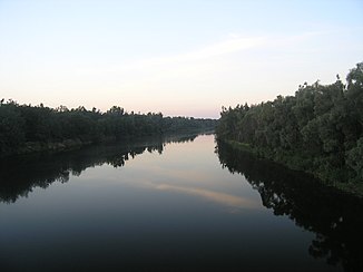
Great Cheremshan
|
Great Cheremshan Большой Черемшан (Bolshoi Cheremshan), Олы Чирмешән, Olı Çirmeşän |
||
| Data | ||
| Water code | RU : 11010000412112100004728 | |
| location | Samara Oblast , Ulyanovsk Oblast , Tatarstan ( Russia ) | |
| River system | Volga | |
| Drain over | Volga → Caspian Sea | |
| source | about 50 km west-southwest of Bugulma in the Bugulma-Belebeier heights 54 ° 20 ′ 0 ″ N , 52 ° 3 ′ 41 ″ E |
|
| muzzle | near Dimitrovgrad in the Kuibyshev reservoir Coordinates: 54 ° 11 '18 " N , 49 ° 39' 56" E 54 ° 11 '18 " N , 49 ° 39' 56" E
|
|
| length | 336 km | |
| Catchment area | 11,500 km² | |
| Drain |
MQ |
35.4 m³ / s |
| Left tributaries | Great Tarchanka , Karmala | |
| Right tributaries | Great Sultscha , Temerlik , Little Cheremshan | |
| Reservoirs flowed through | Kuibyshev reservoir | |
| Medium-sized cities | Dimitrovgrad | |
| Communities | Klyavlino | |
|
Location of the Great Cheremshan (Бол. Черемшан) in the catchment area of the Volga |
||
The Great Cheremshan ( Russian Большой Черемшан ( Bolshoi Cheremschan ); Tatar Олы Чирмешән / Olı Çirmeşän ) is a left tributary of the Volga in Samara Oblast , Tatarstan and Ulyanovsk Oblast in eastern European Russia .
description
The Great Cheremshan rises about 5 km northeast of the village ( Derewnja ) Klyavlino in the Samara Oblast of the same name in the Bugulma-Belebeier Heights near the border with the Republic of Tatarstan. From there it first flows north-west, where it reaches Tatarstan at Tuarma. For several kilometers it now marks the border between Tatarstan and Samara Oblast.
The river curves in a westerly and southwestern direction. At the settlement (Possjolok) Kamenni-Brod it flows again entirely in Samarian territory, where it receives the Great Tarchanka . It then reaches Tatarstan about 10 km northeast of Nurlat . Here it flows in wide curves in a predominantly westerly direction through the south of the Autonomous Republic.
After the confluence of the Great Sultscha and Temerlik , the Great Tschemerschan turns in a south-westerly direction. It reaches the Samara Oblast again, the outermost northwestern tip of which it flows through for only about 10 km, the Karmala and finally overflows the border to the east of the Ulyanovsk Oblast at Novocheremschansk .
Here, after a few kilometers, the Little Cheremshan joins . The Great Cheremshan flows further in west and south-west directions through a valley shaped by mixed pine forests. At Dimitrovgrad the river finally reaches the Volga, which is dammed up to form the Kuibyshev reservoir .
The Great Cheremshan, which is frozen from November to April on average, floods from April to May , where an average of 70% of the annual runoff occurs. The river is very popular with anglers and boaters because of its scenic location.
Individual evidence
- ↑ a b Article Great Cheremshan in the Great Soviet Encyclopedia (BSE) , 3rd edition 1969–1978 (Russian)
- ↑ a b Great Cheremshan in the State Water Register of the Russian Federation (Russian)
- ↑ a b The Great Cheremshan ( page no longer available , search in web archives ) Info: The link was automatically marked as defective. Please check the link according to the instructions and then remove this notice. in the geographical name database of Yandex (russ.)
- ↑ a b Tourist description of the Great Cheremshan (Russian)

