Gubałówka
| Gubałówka | ||
|---|---|---|
| height | 1126 m npm | |
| location | Lesser Poland , northwest of Zakopane | |
| Mountains | Pogórze Spisko-Gubałowskie | |
| Coordinates | 49 ° 18 ′ 27 ″ N , 19 ° 56 ′ 9 ″ E | |
|
|
||
| Development | Funicular | |
The Gubałówka is a 1126 meter high mountain above the Polish city of Zakopane . The mountain is the most famous of the Pogórze Spisko-Gubałowskie mountain range , although it is not the highest - its western neighbor, the Butorowy Wierch , is a little higher at 1160 meters.
On the mountain there is a small settlement with shops and restaurants, but also a small chapel . There is also a transmitter for VHF and TV programs ( RTON Gubałówka ) on the mountain , and a 102 meter high, free-standing steel lattice tower acts as the antenna carrier .
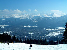
In addition to the views of the resort Zakopane mountain offers views of the Podhale and the south lying Tatra , particularly on known peaks like Giewont and Kasprowy Wierch ( West Tatras ) and Świnica ( High Tatras ).
Funicular
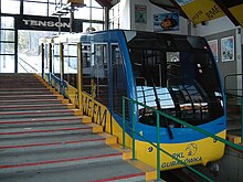
A funicular , which was inaugurated in December 1938 after 168 days of construction, leads up the mountain . The reason for the construction of the track was the Nordic World Ski Championships held in Zakopane in 1939 . The rolling stock and the rails were supplied by the Swiss company Von Roll . In 2001 the railway was completely modernized by the Doppelmayr company . The railway is operated by the Polskie Koleje Linowe (PKL, "Polish Mountain Railways").
The route length is 1298 meters, the difference in altitude 299 meters. The valley station is at an altitude of 823 meters, the mountain station at 1122 meters. The driving speed is 36 km / h, the driving time is around 3½ minutes. A car can accommodate 120 people. The train runs every half hour between 7:30 a.m. and 10:00 p.m., more frequently if necessary. The maximum capacity is 2000 people per hour and direction.
activities
Several hiking routes are marked. In a westerly direction, the route marked with a black trail runs through the valley of Czarny Dunajec . To the west you can also reach the village of Chochołów. A hiking trail leads to Poronin in an easterly direction . The International Mountain Hiking Trail of the Eisenach – Budapest Friendship (marked red here) runs over the Gubałówka .
There are several tow lifts on the mountain for alpine skiing , as well as an illuminated slope. Ski hiking and cross-country skiing are also possible.
Web links
Individual evidence
- ↑ a b zakopane-life.com: Gubalowka Hill
- ↑ lift-world.info: Zakopane (Gubalowka)
- ↑ pkl.pl: Z kart historii (Polish)
- ↑ dw-maria.pl: Kolej linowe ( Memento of the original from December 26, 2008 in the Internet Archive ) Info: The archive link was automatically inserted and not yet checked. Please check the original and archive link according to the instructions and then remove this notice. (Polish)
- ↑ pkl.pl: Kolej Linowo-Terenowa Gubałówka (Polish)


