Gun Island (Houtman-Abrolhos)
| Gun Island | ||
|---|---|---|
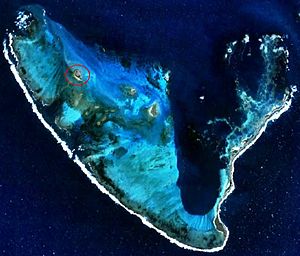
| Location of Gun Island (circled) in the northwest of the Pelsaert Islands. | ||
| Waters | Indian Ocean | |
| Archipelago | Pelsaert Islands ( Houtman Abrolhos Archipelago ) | |
| Geographical location | 28 ° 53 '17 " S , 113 ° 51' 26" E | |
|
|
||
| length | 800 m | |
| width | 400 m | |
| surface | 1.9 ha | |
| Highest elevation | 5 m | |
| Residents | uninhabited | |
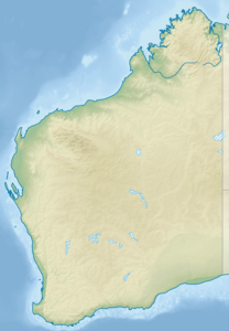
Gun Island is located in the Indian Ocean around 60 km southwest of the western Australian coastal town of Geraldton . The about 19 ha large island is the third largest in the Pelsaert Islands , the southernmost group of islands in the Houtman Abrolhos .
geography
The wedge-shaped and almost vegetation-free island is located in the northwest of Half Moon Reef . About 1 km south is 8 Island , the northernmost island of the Numbered Islands .
history
On June 9, 1727, the Dutch freighter Zeewijk ran aground in Half Moon Reef . Part of the crew was able to save themselves on the nearby island. There the survivors built a small boat called Sloepie from the wreckage of the Zeewijk and other material and flotsam that they found on the surrounding islands . With this last 82 people reached the original port of destination Batavia on April 30, 1728.
In the course of survey trips along the western Australian coast in 1840, a bronze pistol and some coins were found on the island . The captain of this expedition team named the island " Gun Island ".
See also
Individual evidence
- ↑ Kimberly, WB (compiler) (1897). History of West Australia. A narrative of her past. Together With Biographies of Her Leading Men. Melbourne: FW Niven., P.15

