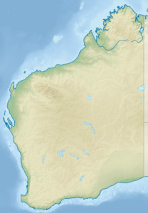
Houtman Abrolhos Archipelago
| Houtman Abrolhos Archipelago | ||
|---|---|---|
|
NASA satellite image of the Houtman Abrolhos Archipelago |
||
| Waters | Indian Ocean | |
| Geographical location | 28 ° 43 ′ S , 113 ° 47 ′ E | |
|
|
||
| Number of islands | 122 | |
| Total land area | 16.4 km² | |
| Residents | uninhabited | |
| Historical nautical chart from 1732 | ||
The Houtman-Abrolhos Archipelago is an island area about 60 km off the coast of Western Australia - at the level of the coastal town of Geraldton .
geography
The archipelago is separated from the mainland by the Geelvink Channel , which is around 50 kilometers wide .
The archipelago includes 122 islands and reefs , which extend over approx. 100 km in the form of a chain of islands running almost parallel to the coast . The group is divided into three island regions, each separated from one another by narrow straits (from north to south):
- Wallabi Islands ( Wallabi Group - including North Island )
- Easter Group
- Pelsaert Islands ( Pelsaert Group )
The largest islands are West Wallabi Island (6.21 km²), East Wallabi Island (3.27 km²), North Island (1.82 km²), Pelsaert Island (1.56 km²) and Rat Island (0.65 km²) . These five islands cover over 82 percent of the total area of the archipelago.
history
The archipelago was discovered by Portuguese sailors at the end of the 16th century. Because of the numerous shallows and rugged coral reefs , some of which are barely visible or only a few centimeters below the water feature, the region was considered extremely dangerous for shipping, especially for the wooden ships of that time. This is why the area was initially named with the made-up word Abrolhos , derived from a Portuguese phrase " abri vossos olhos - keep your eyes open ".
It was not until 1619 that the Dutch astronomer and navigator Frederick de Houtman (1571–1627) mapped the Abrolhos on a research voyage along the west coast of Australia , and named the island area by prefixing his name to Houtman Abrolhos .
One of the treacherous reef banks on the islands was the undoing of the Dutch merchant ship Batavia on June 4, 1629 . The sailing ship ran aground, but the more than 300 people on board were able to save themselves on nearby uninhabited islands. However, the makeshift community of survivors quickly fell apart. The stranded were terrorized and mostly murdered by a group of mutineers from the Batavia led by a failed pharmacist, Jeronimus Cornelisz.
tourism
Because of the numerous ships that have sunk in front of the reefs, the archipelago is now a true paradise for wrecks and scuba divers , even though none of the islands is permanently inhabited by humans.
administration
The islands are administratively part of the Shire of Northampton .
use
All islands are uninhabited. However, 22 of the islands are seasonally populated by over 150 lobster fishermen and their families for a few months .
literature
- Lindsay B. Collins, Zhong Rong Zhu, Karl-Heinz Wyrwoll: Geology of the Houtman Abrolhos Islands . In: HL Vacher, T. Quinn (Ed.): Geology and Hydrology of Carbonate Islands (= Developments in Sedimentology ). tape 54 . Elsevier, Amsterdam 1977, ISBN 0-444-81520-1 , pp. 811–833 ( limited preview in Google Book search).
See also
Web links
- Houtman Abrolhos ( Memento from December 23, 2010 in the Internet Archive ) in the Insel-Encyclopedia www.oceandots.com (English)


