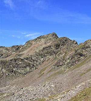
Hörtlanspitze
| Hörtlanspitze | ||
|---|---|---|
|
The Hörtlanerspitze from ONO in the innermost Flaggertal |
||
| height | 2660 m slm | |
| location | South Tyrol , Italy | |
| Mountains | Sarntal Alps | |
| Dominance | 0.88 km → Tagewaldhorn | |
| Notch height | 90 m ↓ Hörtlanerscharte | |
| Coordinates | 46 ° 46 ′ 31 ″ N , 11 ° 29 ′ 6 ″ E | |
|
|
||
| rock | Bressanone quartz phyllite | |
| First ascent | September 16, 1888 by Julius Pock | |
The Hörtlanerspitze (also Hörtlaner Spitze and Hörtlahner Spitze ) is a 2660 m slm high summit in the eastern main ridge of the Sarntal Alps , north of the Flaggerscharte ( 2436 m ) and southwest of the Tagewaldhorn ( 2708 m ). As the pivot point of the east ridge , the most important side ridge, called Sarner Mittelkamm or Gentersbergkamm , branches off to the west. The Flaggerschartenhütte on the Flaggersee is located at the foot of the Hörtlanerspitze . Although the area is often visited, this summit is rarely climbed, and occasionally on a ski tour . The collection of framed Tramintal in the north, the Flaggertal the east and the Durnholzer valley in the southwest. It is located in the municipal areas of Vahrn and Sarntal . A cross with a summit book adorns the summit.
Climbs
All climbs to the Hörtlanerspitze are pathless and require a certain amount of alpine experience. The shortest ascent from the Flaggerschartenhütte over the exposed northeast ridge takes an hour, with a rock wall not far from the summit having to be overcome with the help of a ribbon ( I ). Occasionally, the ridge crossing from the Mutnelle ( 2659 m ) and the arduous ascent from the Tramintal through the north flank and then over the north-west ridge to be won (a good three hours from Asten in the Sarntal ) is used. The latter is particularly considered a winter increase.
Literature and maps
- Helmut Dumler: South Tyrol 2nd area guide. Bergverlag Rother, Munich 1989, ISBN 3-7633-3305-3 .
- Julius Pock : The Sarnthaler Group. Volume II: The Central Alps west of the Brenner. In: Eduard Richter , German and Austrian Alpine Association (ed.): The development of the Eastern Alps. Publisher of the German and Austrian Alpine Club, Berlin 1893, p. 492f.
- Topographic hiking map, Monti Sarentini / Sarntal Alps , sheet 040, 1: 25,000, Casa Editrice Tabacco, ISBN 88-8315-054-6 .

