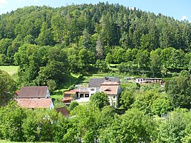
Hammer mill (Egloffstein)
|
Hammer mill (Egloffstein)
Egloffstein market
Coordinates: 49 ° 41 ′ 32 " N , 11 ° 16 ′ 26" E
|
|
|---|---|
| Height : | 362 m above sea level NHN |
| Residents : | 5 (1987) |
| Postal code : | 91349 |
| Area code : | 09197 |
|
The Egloffsteiner district Hammermühle in the foreground, Hammerthoos behind
|
|
Hammermühle is a Franconian wasteland that belongs to Egloffstein .
geography
In the southwest of the Wiesentalb location remote area is one of 16 officially designated districts in the upper Franken located market Egloff stone. It is located about one kilometer southeast of Egloffstein and is at an altitude of 362 m above sea level. NHN .
history
Until the beginning of the 19th century the hammer mill the rule had rich immediate nobles were subject, resulting in the the Frankish knights circle belonging Ritter Canton Gebürg had organized. When the imperial knighthood territories in Franconian Switzerland were mediatized in 1805 , the wasteland was annexed by the Electorate of Palatinate-Baiern in violation of the imperial constitution . With this forcible occupation, the hammer mill finally became part of the New Bavarian territories that were occupied during the Napoleonic land consolidation , which was only subsequently legalized in July 1806 with the Rhenish Federal Act .
As a result of the administrative reforms carried out in the Kingdom of Bavaria at the beginning of the 19th century , Hammermühle became part of the independent rural community of Affalterthal with the second municipal edict in 1818 , which also included the villages of Äpfelbach , Hammerbühl and Schlehenmühle , the hamlet of Hammerthoos and the wasteland of Bärenthal . In the course of the municipal regional reform in Bavaria carried out in the 1970s , Hammermühle was incorporated into the Egloffstein market together with the entire Affalterthal community on May 1, 1978. In 1987 the hammer mill had five residents.
traffic
The connection to the public road network is mainly established by the state road St 2260, which passes directly on the eastern edge of the town . In addition, a community road leading through the neighboring town of Hammerthoos connects the town with the state road St 2191 running a little to the west of it .
Attractions
There are two listed objects in the wilderness, namely a mill and a waterworks.
literature
- Ingomar Bog: Forchheim . In: Historical Atlas of Bavaria . Commission for Bavarian State History, Munich 1955.
- Gertrud Diepolder : Bavarian History Atlas . Ed .: Max Spindler . Bayerischer Schulbuch Verlag, Munich 1969, ISBN 3-7627-0723-5 .
- Federal Statistical Office (Hrsg.): Historical municipality register for the Federal Republic of Germany. Name, border and key number changes in municipalities, counties and administrative districts from May 27, 1970 to December 31, 1982 . W. Kohlhammer, Stuttgart / Mainz 1983, ISBN 3-17-003263-1 .
Web links
- Bavarian official guide for the hammer mill , accessed on September 8, 2019
- The hammer mill in the BayernAtlas , accessed on September 8, 2019
- The hammer mill on a historical map , accessed on September 8, 2019
Individual evidence
- ↑ a b Bavarian State Office for Statistics and Data Processing (Ed.): Official local directory for Bavaria, territorial status: May 25, 1987 . Issue 450 of the articles on Bavaria's statistics. Munich November 1991, DNB 94240937X , p. 301 ( digitized version ). Retrieved September 8, 2019
- ^ Hammermühle in the local database of the Bavarian State Library Online . Bavarian State Library, accessed on September 8, 2019.
- ↑ Geographical location of the hammer mill in the Bayern Atlas , accessed on September 8, 2019
- ↑ Gertrud Diepolder : Bavarian History Atlas . Ed .: Max Spindler . Bayerischer Schulbuch Verlag, Munich 1969, ISBN 3-7627-0723-5 , p. 31 .
- ↑ Gertrud Diepolder : Bavarian History Atlas . Ed .: Max Spindler . Bayerischer Schulbuch Verlag, Munich 1969, ISBN 3-7627-0723-5 , p. 97-103 .
- ↑ Gertrud Diepolder : Bavarian History Atlas . Ed .: Max Spindler . Bayerischer Schulbuch Verlag, Munich 1969, ISBN 3-7627-0723-5 , p. 35 .
- ↑ Gertrud Diepolder : Bavarian History Atlas . Ed .: Max Spindler . Bayerischer Schulbuch Verlag, Munich 1969, ISBN 3-7627-0723-5 , p. 106-107 .
- ^ Ingomar Bog: Forchheim . S. 113 .
- ^ Federal Statistical Office (ed.): Historical municipality directory for the Federal Republic of Germany. Name, border and key number changes in municipalities, counties and administrative districts from May 27, 1970 to December 31, 1982 . W. Kohlhammer, Stuttgart / Mainz 1983, ISBN 3-17-003263-1 , p. 684 .


