Hangard (Neunkirchen)
|
Hangard
City of Neunkirchen
|
||
|---|---|---|
| Coordinates: 49 ° 22 ′ 58 ″ N , 7 ° 12 ′ 38 ″ E | ||
| Height : | 256 m | |
| Residents : | 1803 (December 31, 2018) | |
| Incorporation : | 1st January 1974 | |
| Postal code : | 66540 | |
| Area code : | 06821 | |
|
Hangard location in Saarland |
||
|
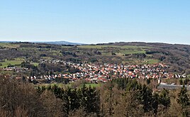
View of the hangard from the Wasserberg or Lichtenkopf in west direction
|
||
Hangard is a district of the district town of Neunkirchen (Saar) located northeast of the city center . Until the end of 1973, Hangard was an independent municipality.
location
Hangard is in the Oster Valley at 260–330 m above sea level.
history
Hangard developed on the former ban of Wiebelskirchen . In 1692 the first settler, Jean Mathieu, settled in the "Hangarden uf der Oster". The old name can also be found in the street name In den Hanggärten . The first residents were French Catholics who settled in the county of Saarbrücken .
As part of the regional and administrative reform in Saarland , the previously independent municipality Hangard was assigned to the city of Neunkirchen on January 1, 1974 .
At the beginning of the 2005 school year, the previously independent primary school in Hangard was merged with the “Friedrich von Schiller” primary school in Wiebelskirchen. The hangard location then served as a branch of the Wiebelskirch elementary school. The school building in Hangard has not been used as a school since the 2012/2013 school year. Since then, all children have been taught in Wiebelskirchen. The former school building has been used as a day nursery since the renovation work was completed in summer 2013 and is used by local associations.
Infrastructure
Hangard is connected to the transport network via the L121, which leads to Wiebelskirchen and Wellesweiler in the south and to Steinbach , Fürth and Münchwies in the north .
In March 2015, the Saarland telecommunications company inexio redeemed a DSL promise for Hangard, in which it was assured that from February 2016 all households in the village will be supplied with a broadband internet connection of up to 100 megabits per second. However, due to a delay in the construction work, this date was postponed by several months. The broadband connections have been available since September 22, 2016.
| year | 1840 | 1880 | 1925 | 1951 | 1977 | 1988 | 2000 | 2015 |
|---|---|---|---|---|---|---|---|---|
| Residents | 410 | 776 | 1,481 | 1,728 | 1,989 | 1,972 | 2,088 | 1,816 |
Premium hiking trail Brunnenpfad
partnership
- After a municipal council resolution of December 21, 1967, Hangard entered into a partnership with the municipality of Enchenberg in Lorraine, which continues to this day.
source
- Website of the district town of Neunkirchen, Hangard district , accessed on August 17, 2010
Individual evidence
- ↑ Neunkirchen: Population status 2018 , accessed on March 24, 2019
- ^ Federal Statistical Office (ed.): Historical municipality directory for the Federal Republic of Germany. Name, border and key number changes in municipalities, counties and administrative districts from May 27, 1970 to December 31, 1982 . W. Kohlhammer, Stuttgart / Mainz 1983, ISBN 3-17-003263-1 , p. 806 .
- ^ Primary school Wiebelskirchen - About us. In: www.grundschule-wiebelskirchen.de. Retrieved October 31, 2016 .
- ^ Saarbrücker Zeitung: The school becomes a day nursery. In: www.saarbruecker-zeitung.de. Retrieved October 31, 2016 .
- ↑ inexio fulfills DSL promise for Hangard - inexio. In: inexio | Connecting your business. Retrieved October 28, 2016 .
- ↑ The data highway for hangards is online - inexio. In: inexio | Connecting your business. Retrieved October 28, 2016 .
- ↑ Katrin Carl, Christian Reuther, Dennis Schuld: Kleine chroNiK. A journey through time through the history of Neunkirchen. District town Neunkirchen 2019. pp. 23–25
Web links
- Homeland and cultural association . Hangard 2007
- Literature about Neunkirchen-Hangard in the Saarland Bibliography


