Wellesweiler
|
Wellesweiler
City of Neunkirchen
Coordinates: 49 ° 20 ′ 47 ″ N , 7 ° 13 ′ 14 ″ E
|
||
|---|---|---|
| Residents : | 5160 (December 31, 2018) | |
| Incorporation : | 1922 | |
| Postal code : | 66539 | |
| Area code : | 06821 | |
|
Location of Wellesweiler in Saarland |
||
|
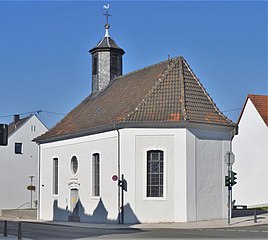
Stengelkirche in Wellesweiler
|
||
Wellesweiler ( ) is a district of Neunkirchen east of Neunkirchen city center between Neunkirchen and Bexbach .
Wellesweiler has a primary school and a community school as well as a stop on the Homburg – Neunkirchen railway line .
geography
location
Wellesweiler is located east of the city center of Neunkirchen on the border of the district of Neunkirchen with the neighboring Saarpfalz district .
Neighboring places
Ludwigsthal is located south of Wellesweiler . The city center of Neunkirchen (Saar), Wiebelskirchen and the town of Bexbach, which belongs to the Saarpfalz district, follow in a clockwise direction .
climate
The annual precipitation is 911 mm. The driest month is September. It rains most in November. 79% of the measuring locations of the German Weather Service show lower values; the precipitation is thus in the upper third. The seasonal fluctuations in precipitation are in the upper quarter. In 75% of all places, the monthly precipitation fluctuates less.
history
Wellesweiler is located at the intersection of two old Roman roads . But archaeological investigations are no longer possible, as the largest industrial settlements in the city are now located in this area. After Bexbach had been added to the Kingdom of Bavaria in 1816, a so-called yardstick , a barrier with a customs station, was erected in 1829 on the Prussian-Bavarian border leading to Wellesweiler .
The completion of a railway line in 1850 made it easier to sell the locally mined coal. The consequent increasing coal mining caused many miners and smelters to settle in Wellesweiler.
The Wellesweiler school was inaugurated in 1887.
In 1922 Wellesweiler was incorporated into the municipality of Neunkirchen, which became a town.
Population development
| year | 1840 | 1880 | 1951 | 1977 | 1988 | 2000 | 2015 |
|---|---|---|---|---|---|---|---|
| Residents | 681 | 1,549 | 5,214 | 6,599 | 9,678 | 5,986 | 5,158 |
Worth seeing
- Kasbruch (Neolithic and Gallo-Roman finds)
- Junker house , a former royal estate, essentially from the 16th century
- Old Protestant church, dated 1757, from the environment of Friedrich Joachim Stengel , simple hall construction
- Palm tree tunnel , probably the oldest preserved tunnel mouth hole in Saarland ( struck in 1816)
Sons and daughters of the place
- Fritz Soot (1878–1965), opera singer
- Ernst Blum (1901–1970), lawyer
- Berthold Günther (1930–1985), zoo director and politician
literature
- Friedrich Bach: Wellesweiler. From farming village to industrial district , Neunkirchen printing and publishing house, Neunkirchen 1983.
- Richard Hilgers: The districts of Neunkirchen . In: Rainer Knauf, Christof Trepesch (eds.): Neunkircher Stadtbuch , Neunkirchen 2005, ISBN 3-00-015932-0 , pp. 709–726.
- Alfons Kolling : A Gallo-Roman spring sanctuary: Kasbruch Neunkirchen Wellesweiler , published by the Foundation Roman Museum Homburg-Saarpfalz. Wellesweiler Working Group for History, Regional Studies and Folk Culture, Neunkirchen-Wellesweiler 2002, ISBN 3-936500-00-2 .
- Bernhard Welter: Timeline: facts and data on current affairs . Association for local history Höcherberg, Bexbach 1995.
- Neunkirchen City Archives, inventory A1 No. 83
- Literature on Wellesweiler in the Saarland Bibliography
Individual evidence
- ↑ Neunkirchen: Population status 2018 , accessed on March 24, 2019
- ^ Jutta Schwan: Railway and train stations in Neunkirchen . In: Rainer Knauf, Christof Trepesch (eds.): Neunkircher Stadtbuch , Neunkirchen 2005, ISBN 3-00-015932-0 , pp. 185–196.
- ↑ Katrin Carl, Christian Reuther, Dennis Schuld: Kleine chroNiK. A journey through time through the history of Neunkirchen. District town Neunkirchen 2019. pp. 23–25


