
Kasbruch
The Kasbruch is a meadow valley near Neunkirchen (Saar) , which lies southeast of the city center in the forest area between Neunkirchen, Wellesweiler , Ludwigsthal and Furpach . The valley is unpopulated and is used for the water supply of the city of Neunkirchen and for local recreation. Since 1998, a 36 hectare nature reserve has been designated here for the “conservation, maintenance and development of a near-natural section of the boggy meadow valleys in the area of the Kasbruchgraben”. The Kasbruch became known nationwide through the Gallo-Roman finds made there .
geography
The meadow valley and the side valleys form a cold air sink. The middle red sandstone is on the valley slopes . The approximately 3 km long main valley runs from west to east; the bottom of the valley is covered with meadows and trees. The approx. 60–80 m wide valley is drained by the Kasbruchgraben , which, according to older maps, flows below the Neunkirchen waterworks into the Erlenbrunnenbach and immediately afterwards with this into the Blies . The Kasbruchgraben is currently open to the site of the waterworks, where it enters a pipeline.
Nature reserve
The species identified in Kasbruch 1951 are shown in Wellesweiler's home book.
The 1998 ordinance on the designation as a nature reserve names the communities that are particularly worthy of protection, such as large sedge , goat's foot , meadow chervil and whistle grass meadows , ear willow bushes , bog birch , black alder , quarry forest and forest fringes. As a protective purpose
“The preservation, care and development of a near-natural section of the boggy meadow valleys in the area of the Kasbruchgraben
for reasons of species and biotope protection, as the biotopes that occur, such as the great sedge, goat's foot, pennilock and pipe grass meadows, ear willow bushes, bog birch-black alder break forest and forest fringes in their interconnectedness of a large number of plants and animals, including rare and endangered, offer a suitable habitat,
because of its special climatic and hydrological conditions,
because of its rarity and special character, which is due to the special location factors and the cultural history with the animal and Flora are determined. "
called.
In 2016, the nature reserve was declared part of the Natura 2000 network under the identifier N 6609-302 with the same name and location .
Surname
The name appears in 1594 as " im Keysbruch " and in 1910 as " der Kasbruch ". Since the middle of the 20th century, the no longer common basic word break for "moist meadow land" has been increasingly clarified by adding the basic word valley . The publications from 1951 and 2002 use " the Kasbruch " and " das Kasbruch Valley " without distinction. The name of the draining brook appears in 1740 as " Kasborn ", in the first recording in the 19th century as " Wellesweiler Mühlenfluss " and on the map as " Kasbruchgraben ". Spang also states that the name Kasbruchgraben appears on TK25 , sheet 6609 Neunkirchen; this is not the case, at least in the 1974 edition. The " Kaskopf " is the top of the upper course . Remy 1951 interprets the local accumulation of names with the defining word “Kas” in such a way that a Gallo-Roman settlement name “kasne” is continued here. However, the determiner is more common in the region, so a local name in the determiner must be excluded. Another "Kasbruch" in the district of Kirkel-Neuhäusel has a very similar landscape; the "Neuhäuseler Arm" nature reserve was established there in 1990. Kolling 2002 used an older regional name for oak as "Kas" for interpretation. The fact that this word continues a Gallo-Roman or pre-Roman * cassanus 'oak' is a coincidence. The Palatinate Dictionary also offers explanations.
Archaeological finds
During reading finds and systematic excavations in 1921/22 by the first conservator of the Saar area Carl Klein and in 1952 by Alfons Kolling on behalf of the state conservator Franz Josef Keller , a number of finds came to light, mainly from the Gallo-Roman period. In particular, the remains of quarries, rock graves and a 12-step rock staircase lie open, and a little four-step rock staircase is hidden next to it. The “Historical Kasbruch Trail” set up by the city of Neunkirchen has the following stations: Roman-era quarry - house foundations - 'Sacrificial stone' quarry - Jungfernstiege / Jungferntrapp - rock graves - sites of reading finds - site of an early Franconian iron melt.
Usage history
In the early modern period, today's forest area between Neunkirchen, Wellesweiler, Ludwigsthal and Furpach formed the Lautzweiler Bann, an uninhabited area whose rulership and hunting rights lay with Nassau-Saarbrücken and pasture and usage rights with the surrounding communities. Its limits are described in 1721. The geographer Tilemann Stella drew the Lautzweiler mill in the lowest part of the Kasbruch in his map from 1564. The Mühlweiher, whose dam still exists today (road from Wellesweiler to Ludwigsthal), was filled by the Kasbruchgraben and by the Hirschgraben branching off from the Erlenbrunnenbach near Stella Enbach. Soon after 1721 the ban was divided between the communities of Neunkirchen and Wellesweiler and the name Lautzweiler fell out of use.
In the place of the Lautzweiler mill, the Wellesweiler mill later stood. This was bought and demolished by the municipality of Neunkirchen in 1874 - together with the water rights belonging to the mill in Kasbruch and Hirschberg. In its place, the Neunkirchen waterworks was built, which today pumps groundwater in the Kasbruch, in the neighboring valley of the Erlenbrunnenbach and, since these springs can no longer meet the city's water needs, also in the Mutterbachtal .
At the place of the "Bürgenweiher" mentioned in 1740 and drained before 1763, the Kasbruch outdoor pool was created in 1927 and existed until 2009. In November 2011 the outdoor pool was dismantled and the area renatured.

Memorial in the Kasbruch
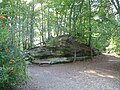
Rocks in the Kasbruch

Source in the Kasbruch
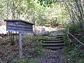
Rock stairs in the Kasbruch


literature
Alfons Kolling : A Gallo-Roman spring sanctuary: Kasbruch Neunkirchen Wellesweiler , Neunkirchen 2002, ISBN 3-936500-00-2
Individual evidence
- ↑ a b Ludwig Lehnen: The Kasbruch near Neunkirchen , hiking map, 1910 (reprinted in Kolling 2002, plate 21)
- ↑ Saarland Official Gazette No. 18, 1998, p. 352
- ↑ a b c d Alfons Kolling : A Gallo-Roman spring shrine: Kasbruch Neunkirchen Wellesweiler , Neunkirchen 2002, ISBN 3-936500-00-2
- ^ A b G. Remy: Heimatbuch von Wellesweiler , Neunkirchen 1951, 2nd edition as an unchanged reprint 1995
- ↑ a b Ordinance on the "Kasbruch" nature reserve. (PDF) In: Saarland Official Gazette . April 30, 1998, accessed July 25, 2020 .
- ↑ Ordinance on the "Kasbruch" nature reserve (N-6609-302). (PDF) In: Saarland Official Gazette . April 28, 2016, accessed July 25, 2020 .
- ↑ Bruch: Palatinate dictionary : 'humid meadow land, sump, moor' , German dictionary : 'humid meadow ground that can be grazed and entered'
- ↑ a b c Rolf Spang : Die Gewässernamen des Saarlandes , Saarbrücken 1982, p. 245. ISBN 3-921646-45-6
- ↑ Chêne: Word meaning and etymology (French)
- ↑ Cheese, m. as field name, gravel, m. as field name, cheese Brünnel, n.
- ↑ Bernhard Welter; Otto L. Ruffing: Bexbach. Heimat am Höcherberg , Bexbach 1999, section Lautzweiler, p. 15 f., Border description 1721, p. 348 f.
- ^ Tilemann Stella: Thorough and thorough description of the baider ambter Zweibrücken and Kirckel, how the same located in 1564 . Editor: Eginhard Scharf. Historischer Verein, Zweibrücken 1993, p. 14, p. 151. ISBN 3-924171-15-7
- ^ Bernhard Krajewski: Chronicle of Kohlhof , Neunkirchen 1934, p. 12
- ↑ The last hour in Kasbruch . In: VIP's Stadtmagazin, Neunkirchen edition, October 2009, p. 19. Kasbruchbad closes its doors . In: es booklet . City magazine Neunkirchen. Vol. 12, issue 138, October 2009. Online ( Memento from February 6, 2013 in the web archive archive.today )
- ↑ Idyllic Kasbruch . In: Wochenspiegel , Vol. 26, No. 32, Neunkirchen edition of August 8, 2012
Web links

Coordinates: 49 ° 20 ′ 10 ″ N , 7 ° 12 ′ 40 ″ E