Hans Kloepfer circular hiking trail
| Hans Kloepfer circular hiking trail | |
|---|---|
 Signpost at the Hirzmann reservoir |
|
| Data | |
| length | 27.8 km |
| location | Voitsberg district , West Styria |
| Supervised by | TVN , ÖAV |
| Markers | HKRW |
| Start / finish point | (Train station) Köflach 47 ° 3 ′ 43.5 ″ N , 15 ° 4 ′ 57.9 ″ E |
| Type | Circular hiking trail |
| Height difference | 780 m |
| The highest point | Noble scrap ( 793 m above sea level ) |
| Lowest point | Gößnitzbach near Kreuzberg (443 m above sea level) |
| Level of difficulty | light |
| season | all year round |
The Hans-Kloepfer-Rundwanderweg ( HKRW marking ) is a circular hiking trail in the Austrian state of Styria . The approximately 28-kilometer circular route leads through the Voitsberg district and is named after the doctor and dialect poet Hans Kloepfer, who was controversial because of his NSDAP membership and admiration for Adolf Hitler .
course
Starting from the Köflach train station, the path leads counter-clockwise through the city center and up to the pilgrimage site of Maria Lankowitz . In a semicircle around an extensive golf course you come to a riedel above the Gößnitzbach and hike down to Packer Straße . From there the hiking trail leads to Edelschrott , at 793 m above sea level. A. highest point of the tour. 30 minutes later you reach the Hirzmann reservoir , which was built on the Teigitsch , and walk along its northeast bank. Before reaching the dam, the path branches off to the left and leads gently up and down to Sankt Martin am Wöllmißberg . A longer descent into the Gößnitzgraben is followed by the last ascent to the Ungerhof in Rosental - Puchbach . In the vicinity of the Köflach coal mining area, the Hans Kloepfer circular hiking trail leads back to the starting point via Schaflos.
Condition of the path, walking time and height difference
The Hans-Kloepfer-Rundwanderweg runs mostly on easy hiking trails and is continuously marked. The nature of the path ranges from asphalt roads to cart paths to narrow footpaths. With a length of almost 28 kilometers, the path requires a certain amount of stamina if it is to be done within a day. The walking time is usually between seven and nine hours. In terms of height profile, the tour consists of a larger ascent of about 300 meters (against the UZS to Edelschrott) and several small climbs that are spread over the entire route. The route profile is flat, especially along the reservoir. In addition to Köflach, Edelschrott can also be reached by GKB public transport and can serve as the starting or end point of the circular hike.
Attractions
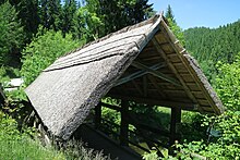
Along the route there are several sights of cultural importance and popular excursion destinations. Of architectural interest are the Franciscan monastery Maria Lankowitz with a several times enlarged, baroque monastery church as well as the parish church of St. Laurentius in Edelschrott and the parish church of Sankt Martin am Wöllmißberg . The Ströhberne Bruck'n from 1816, which originally spanned the Teigitsch and was moved to a side stream after the Hirzmannsperre was built, is a few minutes' walk away from the hiking trail in the community of Edelschrott . Another detour is to the lower end of the Hirzmann reservoir, where the highest vaulted dam in Styria is located at almost 59 meters . In Sankt Martin, next to the parish church, there is the Wöllmißberger Heimatmuseum , which is located in the former elementary school. The reservoir can be used as a natural swimming lake.
Literature and maps
- Freytag & Berndt Vienna , hiking map 1: 50,000, WK 132, Gleinalpe - Lipizzanerheimat - Voitsberg , ISBN 978-3850848039 .
- Austrian map 1: 50,000, pages 4228/4104 ( UTM ). Federal Office for Metrology and Surveying .
Web links
Individual evidence
- ↑ Hans Kloepfer Rundwanderweg (HKRW). outdooractive, accessed on May 16, 2020 .

