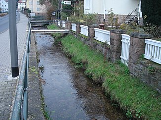
Hazel (orb)
|
Hasel Haselbach |
||
|
The hazel in Bad Orb |
||
| Data | ||
| Water code | DE : 2478524 | |
| location |
Hessian-Franconian mountainous region
|
|
| River system | Rhine | |
| Drain over | Orb → Kinzig → Main → Rhine → North Sea | |
| source | in Haselbachtal at the cabin hazel rest 50 ° 13 '30 " N , 9 ° 24' 18" O |
|
| Source height | 280 m above sea level NHN | |
| muzzle | in Bad Orb in the Orb coordinates: 50 ° 13 ′ 40 ″ N , 9 ° 20 ′ 55 ″ E 50 ° 13 ′ 40 ″ N , 9 ° 20 ′ 55 ″ E |
|
| Mouth height | 160 m above sea level NHN | |
| Height difference | 120 m | |
| Bottom slope | 24 ‰ | |
| length | 4.9 km | |
| Catchment area | 14 km² | |
The Hasel or Haselbach is a right tributary of the Orb in the Main-Kinzig-Kreis in the Hessian Spessart .
geography
Hazel spring
The hazel rises from the hazel spring at Jagdhaus Haselruhe in a clearing strip between mixed forest in the north and coniferous forest in the south at the western foot of the Markberg .
The spring was dammed for fish farming. Trout live in the crystal clear water of the Hasel spring . The spring water is then fed into another pond.

course
The Hasel flows mainly in a westerly direction between the Kleine Marktberg ( 364 m above sea level ) in the north and the Wintersberg ( 434 m above sea level ) in the south through the almost untouched Haselbach valley to Bad Orb .
There the hazel finally flows out at a height of about 160 m above sea level. NHN a little east of Bahnhofstrasse from the right into the Orb approaching from the southeast .
Its 4.9 km long run ends 120 meters below its source, so it has a mean bed gradient of 24 ‰.
Catchment area
The catchment area of the Hasel lies in the Sandstone Spessart and is drained to the North Sea via the Orb, Kinzig , Main and Rhine rivers.
It borders
- in the north and northeast to that of the Klingbach , a tributary of the Kinzig
- and in the east to that of the Jossa , a tributary of the Sinn , which drains over the Franconian Saale into the Main
- to the south to that of the Orb
- and in the north to that of the Kinzig
The highest point is the 516 m high Markberg in the east of the catchment area.
The catchment area is predominantly forested. The settlement areas of Bad Orb are located in the estuary area.

