Hassa (Hatay)
| Hassa | ||||
|
||||
| Basic data | ||||
|---|---|---|---|---|
| Province (il) : | Hatay | |||
| Coordinates : | 36 ° 48 ' N , 36 ° 31' E | |||
| Height : | 430 m | |||
| Residents : | 9,218 (2010) | |||
| Telephone code : | (+90) 326 | |||
| Postal code : | 31710 | |||
| License plate : | 31 | |||
| Structure and administration (as of 2011) | ||||
| Mayor : | Mehmet Karataş ( AKP ) | |||
| Website: | ||||
| Hassa district | ||||
| Residents : | 54,287 (2010) | |||
| Surface: | 495 km² | |||
| Population density : | 110 inhabitants per km² | |||
| Kaymakam : | Harun Başıbüyük | |||
| Website (Kaymakam): | ||||
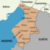
Hassa is a district town and capital of the district of the same name in the Turkish province of Hatay . Hassa is in the north of the province and borders the Gaziantep Province . In the east, Hassa borders the Syrian Governorate of Aleppo . The city has 9218 and the district 54,287 inhabitants (as of 2010). The city of Hassa lies at the foot of the Amanos Mountains . The majority of the district is otherwise mountainous. The highest peaks are the Mığır (2240 m) and the Kuşcu (2076 m). Forests occupy 256 km² of the area. The main rivers and streams are Karasu, Hopur, Tiyek, Akbez and Hacılar. The climate is Mediterranean with highs in August and lows in January.
The city was founded in the 1860s. The place name comes from the special unit that was then used under the command of Ibrahim Dervish Pasha to bring tribes to reason in the Gâvur Dağları .
Individual evidence
- ↑ a b Turkish Institute for Statistics ( Memento from December 5, 2012 in the web archive archive.today ), accessed on May 22, 2011
- ↑ Sevan Nişanyan : Adini unutan Ülke. Türkiye'de Adı Değiştirilen Yerler Sözlüğü. Istanbul 2010, p. 169


