Dörtyol
| Dörtyol | ||||
|
||||
| Basic data | ||||
|---|---|---|---|---|
| Province (il) : | Hatay | |||
| Coordinates : | 36 ° 51 ' N , 36 ° 13' E | |||
| Residents : | 117,053 (2014) | |||
| Telephone code : | (+90) 326 | |||
| Postal code : | 316xx | |||
| License plate : | 31 | |||
| Structure and administration (as of 2015) | ||||
| Mayor : | Yaşar Toksoy ( MHP ) | |||
| Website: | ||||
| Dörtyol district | ||||
| Residents : | 117,053 (2014) | |||
| Surface: | 600 km² | |||
| Population density : | 195 inhabitants per km² | |||
| Kaymakam : | Recep Soytürk | |||
| Website (Kaymakam): | ||||
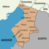
Dörtyol is a district town in the Turkish province of Hatay . At the same time, Dörtyol is the capital of the district of the same name . Dörtyol is located in the north of the province on the Mediterranean . A small part borders the provinces of Gaziantep and Osmaniye . Since a regional reform in 2014, the district is identical in terms of area and population to the district town. Dörtyol means "crossroads" in German (literally: "four ways") and illustrates the importance of the city as a crossing point between Anatolia and Syria .
Dörtyol belonged to the Republic of Turkey since 1923. The city was part of the Adana Province. Today's Hatay Province was a French mandate until 1938 and was briefly independent as the State of Hatay from 1938 to 1939 . In 1939 Hatay was annexed to Turkey and Dörtyol became part of the new province.
Attractions
Near Dörtyol, the archaeological site Kinet Höyük is believed to be the ancient site of Issos , where 333 BC. The battle of Issus took place.
Web links
Individual evidence
- ↑ a b Turkish Institute for Statistics ( Memento from December 13, 2015 on WebCite ), accessed December 13, 2015


