Yayladağı
| Yayladağı | ||||
|
||||
| Basic data | ||||
|---|---|---|---|---|
| Province (il) : | Hatay | |||
| Coordinates : | 35 ° 54 ' N , 36 ° 4' E | |||
| Height : | 415 m | |||
| Residents : | 6,471 (2010) | |||
| Telephone code : | (+90) 326 | |||
| Postal code : | 31550 | |||
| License plate : | 31 | |||
| Structure and administration (as of 2011) | ||||
| Mayor : | Mustafa Kemal Dağıstanlı ( MHP ) | |||
| Website: | ||||
| Yayladağı County | ||||
| Residents : | 22,529 (2010) | |||
| Surface: | 366 km² | |||
| Population density : | 62 inhabitants per km² | |||
| Kaymakam : | Tolga Polat | |||
| Website (Kaymakam): | ||||
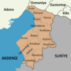
Yayladağı (formerly Ordu ) is a district town in the Turkish province of Hatay . At the same time, Yayladağı is the capital of the Yayladağı district of the same name . Yayladağı is located on the southern tip of the Mediterranean . The district forms the southernmost part of Turkey and borders Syria ( Idlib and Latakia governorates ). To the west there is the border crossing called Yayladağı Gümrük Kapısı . The city has 6,471 and the district 22,529 inhabitants (as of 2010).
Web links
Commons : Yayladağı - album with pictures, videos and audio files
Individual evidence
- ↑ a b Turkish Institute for Statistics ( Memento from December 5, 2012 in the web archive archive.today ), accessed on May 22, 2011


