Hem (Aa)
|
Hem Tiret |
||
|
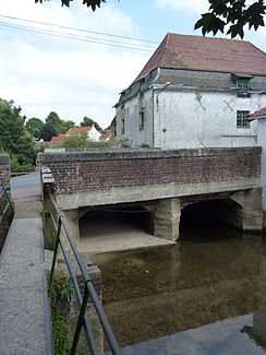
Mill in Tournehem-sur-la-Hem |
||
| Data | ||
| Water code | FR : E4100600 , FR : E4300600 | |
| location | France , Hauts-de-France region | |
| River system | Aa | |
| Drain over | Aa → North Sea | |
| source | in the local area of Escœuilles 50 ° 45 ′ 34 ″ N , 1 ° 55 ′ 35 ″ E |
|
| Source height | approx. 113 m | |
| muzzle | in the municipal area of Audruicq in the Canal de Calais à Saint-Omer and thus in the water system of the Aa Coordinates: 50 ° 53 ′ 12 ″ N , 2 ° 7 ′ 7 ″ E 50 ° 53 ′ 12 ″ N , 2 ° 7 ′ 7 ″ O |
|
| Mouth height | approx. 2 m | |
| Height difference | approx. 111 m | |
| Bottom slope | approx. 4.1 ‰ | |
| length | approx. 27 km | |
| Discharge at the Tournehem A Eo gauge : 105 km² |
MQ Mq |
1.5 m³ / s 14.3 l / (s km²) |
The Hem is a river in France that runs in the Pas-de-Calais department in the Hauts-de-France region . It rises in the hills of the Haut-Artois , in the Caps et Marais d'Opale Regional Nature Park , in the municipality of Escœuilles and reaches the plains at Policove . Here the river branches off into the two drainage waters Meulestroom and Tiret . The main drain, Meulestroom, is built like a canal and continues in a north-easterly direction to Hennuin , in the municipality of Audruicq , where it flows into the Canal de Calais à Saint-Omer and thus reaches the Aa water system .
history
Before the Hennuin lock was installed , the river crossed the Canal de Calais á Saint-Omer with a culvert , often sunk in mud , to supply the Canal du Mardick , which flows into the Aa at Saint-Folquin , with water. The mouth of the Canal du Mardick was thus the actual mouth of the Hem River . With the expansion of the Canal de Calais à Saint-Omer in 1989, however, the culvert was closed and the river was de facto cut in two. Confusingly, the official French river database SANDRE names the upper course of the river primarily with the name "Tiret" and only the cut-off lower course with the name "Hem".
Places on the river
(Order in flow direction)
- Hocquinhem
- Clerques
- Bonningues-lès-Ardres
- Tournehem-sur-la-Hem
- Zouafques
- Nordausques
- Recques-sur-Hem
- Polincove
- Hennuin , Audruicq parish
Hydrology
While the river has retained its natural bed in the upper reaches, it has been widened and straightened in the lower reaches. After a distance of about 25 kilometers, the river divides into the two arms of Meulestroom and Tiret in Polincove .
- The Tiret branches below Muncq-Nieurlet again into the Robecq and the Liettre . Both flow into the Canal de Calais á Saint-Omer and into the canalised Aa .
- Below Polincove, the Oudrecq watercourse branches off from the Meulenstroom to the left , which also diverts part of the river water to the d'Audruicq Canal .
Floods mainly occur in the winter months.
Web links
- Agence de l'Eau Artois-Picardie: "Vallée de la Hem"; PDF file (French)
- Description of the river bifurcation at Polincove (French)
Individual evidence
- ↑ Source geoportail.gouv.fr
- ↑ estuary geoportail.gouv.fr
- ↑ Water information system Service d'Administration National des Données et Référentiels sur l'Eau (French) ( information ), accessed on April 24, 2015, rounded to full kilometers
- ↑ hydro.eaufrance.fr (station: E4306010 , option: Synthèse ) .
