Hermann Haack (cartographer)

Hermann Haack (born October 29, 1872 in Friedrichswerth ; † February 22, 1966 in Gotha ) was a German cartographer .
Life
Hermann Haack came from a humble background. His father ran a post office in Friedrichswerth. From 1878 to 1883 Haack attended the local elementary school. By chance he made the acquaintance of Bernhard Perthes , who supported him financially and made it possible to study in Halle . In the spring semester of 1893 Haack began studying geography and cartography there .
He later moved to the University of Göttingen , where he became a student of cartographer Hermann Wagner . Through its recommendation Haack was then in Berlin assistant of Ferdinand von Richthofen . In 1896 Haack successfully completed his studies with his dissertation "About the Middle Height of South America ".
After completing his military service in 1897 as a one-year volunteer , Haack got a permanent job at the Justus Perthes Geographic Institute in Gotha, where he had worked from time to time as a student. The first major project in which Haack was involved was the "German School Atlas" by his teacher Richard Lüddecke . After his early death in 1888, Hermann habenicht took over this function.
From 1898 Haack was in charge of the development of Perthes' school wall maps . Three editions (geographical, historical, physical) were made of each map. Very strong colors ensured that the main map contents in the classrooms were easily recognizable from a distance. Here he continued the existing color symbols for physical maps: green = level; red = cities; blue = body of water; brown = mountains. This "physical coloring" (also: physical color), which was developed by Justus Perthes in the 19th century, has hardly lost its importance for school lessons to this day.
Haack was also significantly involved in a complete revision of Stieler's Hand Atlas . The tenth edition appeared from 1920 to 1944 in several deliveries with over 250 cards ( engraved in copper ).
In 1903 Haack founded the magazine Geographischer Anzeiger . When he founded the Association of German School Geographers in 1912 , this magazine functioned as a club magazine. The association was the 1935 DC circuit in the NS teacher's union incorporated (start-up in 1949 in the Federal Republic of Germany). In 1944 Haack retired into private life. After the end of the war, the then Soviet occupying power brought Haack back to the Geographical Institute, where he worked almost until the end of his life. He was considered a confidant by the occupying power and later in the GDR, since he had been a "Corresponding Member of the Geographical Society of the USSR" since 1932.
After the expropriation without compensation by the Gotha City Council in January 1953, the now state- owned Justus Perthes Verlag in Gotha was renamed VEB Hermann Haack Geographisch-Kartographische Anstalt Gotha in October 1955 . Haack Gotha was the GDR's monopoly publisher for cartographic school publications (mainly atlases and wall maps) until 1989. After the successful reprivatisation, the publishing house changed its name to Justus Perthes Verlag Gotha GmbH in 1992 . Since then he has been part of the Klett Group ; since 2003 as Klett-Perthes Verlag . On March 31, 2016, the last publishing activities of the former House of Justus Perthes also expired after more than 230 years in Gotha.
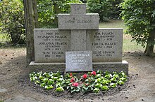
Hermann Haack's tombstone - restored in 2014 with a donation from Stephan Justus Perthes - is now in the grove of honor at the main cemetery in Gotha .
Awards
- 1942: Goethe Medal for Art and Science
- 1952: Honorary doctorate from the Friedrich Schiller University in Jena
- 1953: Alexander von Humboldt Medal from the Society for Geography in Berlin
- 1953: Honorary citizenship of Gotha and Friedrichswerth
- 1953: National Prize of the GDR
- 1957: Patriotic Order of Merit in silver
literature
- Short biography for: Haack, Hermann Otto . In: Who was who in the GDR? 5th edition. Volume 1. Ch. Links, Berlin 2010, ISBN 978-3-86153-561-4 .
- Bauerfeind, Günter: Hermann Haack 1872–1966 - Nestor of German cartography. Series of publications of the Urania culture and education association Gotha eV Gotha 2009: Urania.
- Brogiato, Heinz Peter: "Knowledge is power - geographical knowledge is world power". The school geographic journals in German-speaking countries (1880–1945) with special consideration of the geographical display. Materials for Didactics of Geography, Volume 18, Part 1, Trier 1998: Geographische Gesellschaft Trier (here pp. 153–167).
- Henniges, Norman & Philipp Julius Meyer: “The overall picture of the fatherland always in front of your eyes”: Hermann Haack and the Gotha school cartography from the Wilhelmine Empire to the end of National Socialism. In: Zeitschrift für Geographiedidaktik, Volume 44, Issue 4 (2016), pp. 37–60.
- Langer, Helmut: Hermann Haack. Creator of the wall atlases. ed. v. Urania Kultur und Bildungsverein Gotha eV, Gotha geoscientist in 220 years, Gotha 2005: msb kommunikation, pp. 36–38.
Individual evidence
- ↑ Information board at the house where he was born
Web links
- Detailed curriculum vitae of Hermann Haack (MDR)
- Literature by and about Hermann Haack in the catalog of the German National Library
- Timeline of the history of the Justus Perthes publishing house, Gotha and Darmstadt
| personal data | |
|---|---|
| SURNAME | Haack, Hermann |
| ALTERNATIVE NAMES | Haack, Hermann Otto |
| BRIEF DESCRIPTION | German cartographer |
| DATE OF BIRTH | October 29, 1872 |
| PLACE OF BIRTH | Friedrichswerth in Thuringia |
| DATE OF DEATH | February 22, 1966 |
| Place of death | Gotha |


