Heuberg (Hofgeismar City Forest)
| Heuberg | ||
|---|---|---|
|
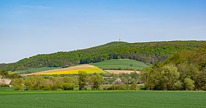
Heuberg bei Hofgeismar from the west-southwest |
||
| height | 392 m above sea level NHN | |
| location | at Hofgeismar ; District of Kassel , Hessen ( Germany ) | |
| Mountains | Hofgeismar city forest in the mountains of Lower Saxony | |
| Coordinates | 51 ° 31 '13 " N , 9 ° 20' 58" E | |
|
|
||
The Heuberg (previously called Hoi-Berg = high mountain ) near Hofgeismar in the Kassel district , northern Hesse , is 392 m above sea level. NHN the highest mountain of the Hofgeismar city forest and at the same time of the entire Oberwälder Land , a natural spatial unit of the Lower Saxon mountainous region .
geography
location
The Heuberg rises in the Hofgeismar city forest about 3.7 km northwest of the center of Hofgeismar . To the north-northeast lies Eberschütz (to Trendelburg ), to the northwest Lamerden (to Liebenau ), both of which are traversed by the Diemel , and to the south-west of Ostheim (to Liebenau).
The east-south-east neighbor of the Heuberg is the Westberg , which at around 340 m is the second highest point of the ridge. Its northeast branch is the Olmesberg (approx. 334 m ), its southwest branch the Arensberg (approx. 335 m ). To the east, across the Esse valley, rises the Schöneberg ( 323.2 m ) with the Schöneberg castle ruins .
Natural allocation
The Heuberg heard in the natural environment Greater Region 3rd order of Lower Saxony uplands to the main unit group Upper Weserbergland (no. 36) to the main unit Oberwälder Land (361), now synonymous with the former entity Brakeler limestone region (361.0), and the natural environment Bever-Diemel Kalkberg Country (361.02). Within unit 361.02, it is part of the southern part of Liebenauer Bergland .
Protected areas
On the northwest flank of the Heuberg lies the nature reserve Kalkmagerrasen and Diemelaltwasser near Lamerden ( CDDA no. 163989; designated in 1989; 18 ha in size) with the LSG of the same name (CDDA no. 378495; 1986; 16 ha) and FFH area (FFH- No. 4422-303; 17 ha).
various
A wooden observation tower had stood on the Heubergkuppe since 1957, which was demolished because it was dilapidated and replaced by a broadcasting / television tower . The type FMT 9/84 transmission tower has a height of 58.0 m and an attachment (antenna) 18.0 m high. It lies at an altitude of 376 m above sea level. There are several hiking trails around the mountain, including circular hiking trail 6. Old finds point to a prehistoric past.

