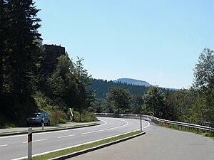
Hindenburg pulpit
| Hindenburg pulpit | ||
|---|---|---|
|
The Hindenburg pulpit seen from the parking lot below the pulpit |
||
| height | 1062 m above sea level NHN | |
| location | Bavaria | |
| Mountains | Bavarian forest | |
| Coordinates | 49 ° 8 '50 " N , 13 ° 9' 26" E | |
|
|
||
| rock | Gneiss | |
The 1062 m above sea level. NHN high Hindenburgkanzel is a protruding rock bar in the northern Bavarian Forest on the border between Upper Palatinate and Lower Bavaria .
It is located directly above Brennesstrasse, which leads from Lohberg in the Upper Palatinate district of Cham to Bayerisch Eisenstein in the Lower Bavarian district of Regen . In addition, the viewing platform is between the Zwercheck and Arber mountains ; from here you can enjoy a very good view of the Lamer Winkel and the Osser .
Emergence
The viewing platform was exposed during the construction of the Scheibenstrasse, which leads from Lamer Winkel up to Brennesstrasse . The construction workers encountered an obstacle while building the road - the red tariff bolt. In order to circumnavigate the colossus and to build the road at a reasonable incline, part of the bolt was blown away. What was left was the impressive rock pulpit. Those responsible named the viewing platform in honor of the then Reich President and Field Marshal Paul von Hindenburg in Hindenburgkanzel. On the Hindenburg pulpit, a memorial plaque commemorates the 50th anniversary of the Bavarian Forest Association (founded in 1883).

