
Hirtstein (Ore Mountains)
| Hirtstein | ||
|---|---|---|
 The Hirtstein seen from the southeast |
||
| height | 889.8 m above sea level NHN | |
| location | Erzgebirgskreis , Saxony ( Germany ) | |
| Mountains | Ore Mountains | |
| Coordinates | 50 ° 32 '11 " N , 13 ° 11' 36" E | |
|
||
| Type | Spring tip | |
| rock | basalt | |
| Age of the rock | 24 million years | |

.jpg)
The Hirtstein is 889.8 m above sea level. NHN high mountain with statutes in the upper Ore Mountains in Saxony not far from the German - Czech border in the Ore Mountains District .
It is known for its geologically remarkable fan-shaped basalt outcrop, which was exposed by a quarry that has since been closed.
At the summit is a historic station of the Royal Saxon Triangulation from 1863.
The Hirtstein lies in the area of the city of Marienberg and is its highest mountain, but not its highest point, as is often claimed. South of the mountain, not far from the border with the Czech Republic, there is a point that is 899.4 m above sea level. NHN is higher than the summit of the Hirtstein.
geology
The peculiarity of the Hirtsteins is defined by a basalt - Intrusion resultant basalt compartments , having the form of an oversized flower or a palm frond.
The columnar cleavage of the basalt is caused by stress cracks across the temperature gradient during cooling. The basalt lava did not reach the surface during the Hirtstein volcanic event around 25 million years ago, but solidified to form an underground dome.
The outcrop is one of many magmatite deposits of various origins in the area of and around the Ore Mountains, formed by magmatism in today's Egertalgraben during the Tertiary period .
So far (as of 2015) the minerals augite , magnetite , nepheline , olivine and perovskite have been detected in various basalt samples from the Hirtstein .
History and ways
The basalt fan was exposed by quarrying. As early as the end of the 19th century, the columnar positions of the basalt, which became more and more evident in the course of the quarry operation, brought the idea of protection to the fore. In negotiations with the owners, considerate mining of the rock was achieved so that geologically valuable sites were preserved.
The outcrop on the Hirtstein was named in May 2006 by the Hanover Academy of Geosciences as one of the 77 most important national geotopes in Germany. The Hirtstein is a natural monument and a lookout point .
On the summit is the Hirtsteinbaude, a well-known excursion restaurant in the region. The inauguration of the Hirtsteinbaude with restaurant and several hotel rooms took place on September 11, 1927. A wind park with five wind turbines has been on the mountain since 1992. This was the first wind farm in Saxony. Several cross-country trails are groomed on the Hirtstein in winter. The Erzgebirge / Krušné hory ski route leads over the mountain . There is a small ski, snow tube and toboggan slope with a lift right next to the chalet.

Basalt fan or "palm fronds"

Information board about the geotope

The Hirtsteinbaude in winter
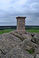
Station 85 Hirtstein of the Royal Saxon Triangulation


literature
- Gerald Urban: The Hirtstein in statutes - a prevented volcano In: Erzgebirgische Heimatblätter , 2/2009, pp. 2–3, ISSN 0232-6078
Individual evidence
- ↑ a b Saxony Atlas of the Free State of Saxony ( notes )
- ↑ https://www.umwelt.sachsen.de/umwelt/geologie/10002.htm Kurt Goth: Palmenwedel Hirtstein , article in Important Geotopes of Saxony , website of the Saxon State Ministry for Environment and Agriculture, accessed on May 21, 2017
- ↑ Werner Paelchen, Harald Walter (Ed.): Geology of Saxony . Stuttgart (Schweizerbart) 2008, pp. 486–489. ISBN 978-3-510-65239-6
- ^ Mineralienatlas : type locality Hirtstein, description of the place of discovery and mineral list
- ↑ Description of the Hirtstein in Erzgebirgische Heimatblätter , 2/2009, p. 3
Web links
- The shepherd stone. Website of the community statutes in the Erzgebirge
- Videos from the Hirtstein Videos from the basalt fan on the Hirtstein
- Hirtstein palm fronds. Description of the geotope at the Saxon State Office for Environment, Agriculture and Geology