Hochstaff
| Hochstaff | ||
|---|---|---|
|
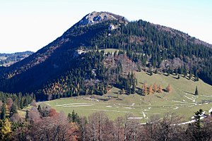
Hochstaff from the southwest (ascent to the Reisalpe ) |
||
| height | 1305 m above sea level A. | |
| location | Lower Austria , Austria | |
| Mountains | Gutenstein Alps | |
| Dominance | 2.1 km → Reisalpe | |
| Notch height | 293 m ↓ Kleinzeller Hinteralm | |
| Coordinates | 47 ° 58 '14 " N , 15 ° 41' 24" E | |
|
|
||
| rock | Dachstein Limestone | |
| Age of the rock | Norium - Rhaetium | |
| Normal way | Hike on unmarked path | |
The Hochstaff is 1305 m above sea level. A. high mountain in the Gutenstein Alps in Lower Austria .
Location, character and name of the mountain
The Hochstaff - one of the distinctive foothills of the Alps in Lower Austria - rises 3.5 kilometers west-southwest of the town center in the municipality of Kleinzell . A saddle near the Kleinzeller Hinteralm separates it from the south-west neighboring Reisalpe , which is 1399 m above sea level. A. forms the highest peak in the entire Gutenstein Alps .
The Hochstaff is easy to recognize by its characteristic shape: its western flank is very steep and partly interspersed with rocks; however, towards the east it slopes much more gently. The summit, on which there is a cross erected by the mountain rescue service , offers a beautiful view that is only restricted to the southwest by the higher Reisalpe. The free panorama to the west and the view down to the Ebenwaldhöhe in the north are particularly impressive .
The name of the Hochstaff is most likely derived from the Middle High German word stouf , which means drinking cup . The name (steep) -staff- is borne by several Austrian mountains with a distinctive summit structure, whose shape is reminiscent of an inverted cup.
Ebenwaldhöhe
The slightly undulating high plateau of the Ebenwaldhöhe begins immediately north of the Hochstaff and extends more than 3 kilometers to the northeast to the Schwarzwaldeck . It is between 1000 and 1100 meters above sea level and is loosely populated with a few large farms . The Ebenwaldhöhe can be reached from Kleinzell via an asphalt road that used to be tolled and has been freely passable for several years. The plateau is ideal for hikes and at the same time forms a high point of departure for the Hochstaff and the Reisalpe.
Due to the sparsely populated environment and the often clear air at medium altitudes, the Ebenwaldhöhe offers particularly favorable conditions for astronomers .
Climbs
It is somewhat surprising that there is no marked ascent on the promising Hochstaff today. (An old marked path was abandoned long ago and not re-established.) However, the summit can be reached on several unmarked routes.
- The shortest ascent begins just south of the parking lot on the Ebenwaldhöhe. First over pastures, then up steep and somewhat bumpy in the forest. Walking time: 1 hour
- From the Ebenwaldhöhe car park on a forest road at almost the same height to the saddle in front of the Kleinzeller Hinteralm, then partly over alpine pastures from the south a little more pleasant to the summit. Walking time: about 1½ hours
- From Kleinzell on the marked path to the Weißenbachalm , further over a series of clearings in the gentle eastern flank of the Hochstaff to the summit. Walking time: about 2½ hours
These increases can be combined with one another as required.
In winter the Hochstaff is a popular destination for easy ski tours . If there is enough snow, the ski tour can start in the Schneidergraben just west of Kleinzell. The summit can be reached without difficulty via the clearings in the upper part of the eastern flank.
literature
- Franz Hauleitner: Ötscher. Mariazell - Türnitz - Traisentaler Berge , Bergverlag Rudolf Rother , Munich 2010, 4th edition. ISBN 978-3-7633-4026-2
- Adi Mokrejs: Bergwanderatlas Niederösterreich , Schall-Verlag, Alland 2012, 2nd edition. ISBN 978-3-900533-66-3
Web links
- Unmarked to a worthwhile summit : hiking tip from the daily Der Standard , October 29, 2010
- Hochstaff Ostanstieg : Description of ski tours on www.bergstieg.com
Remarks
- ↑ Overview by Heinz-Dieter Pohl on mountain names in Austria
- ↑ See the recommendation of the Vienna Working Group for Astronomy on their homepage

