Hohbirker Kunstgraben
| Hohbirker Kunstgraben | ||
|
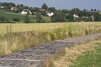
The Hohbirker Kunstgraben west of Berthelsdorf. The transition from rind to concrete slab cover is clearly visible . |
||
| Data | ||
| location | Germany | |
| River system | Elbe | |
| Drain over | Münzbach → Freiberger Mulde → Mulde → Elbe → North Sea | |
| source | northeast of the Rothbächer pond 50 ° 51 ′ 30 ″ N , 13 ° 20 ′ 44 ″ E |
|
| muzzle | west of Langenrinne in the Münzbach Coordinates: 50 ° 53 '10 " N , 13 ° 21' 15" E 50 ° 53 '10 " N , 13 ° 21' 15" E
|
|
| length | 4.8 km | |
The Hohbirker Kunstgraben (also: Hohe Birke Kunstgraben and Hochbirkner Kunstgraben ) is an Erzgebirge artificial ditch from the 16th century. He fed impact water from Brand-Erbisdorf to the pits on the Hohbirker Gangzug in the Freiberg district of Zug .
course
The 4.805 kilometer long ditch begins as the confluence of the outflow from the Rothbächer pond and part of the water from the Müdisdorf artificial ditch . It then runs north to Krausen's mill , where it has gone a short distance . Then it swings slightly in a north-north-easterly direction and leads east past the former Mendenschacht (also: Zugspitze ). Over the so-called Mendenrösche impact water for conveying and dewatering of the mine was chipped from the artificial moat. In front of the former train stop, it crosses the Berthelsdorf – Großhartmannsdorf railway line and shortly afterwards feeds the Konstantinteich . Then it runs in a long east curve northwards to about the center of Zug.
At the chapel in Zug is the end point of the Hohbirker Kunstgraben, which originally with its branches extended into the southern urban area of Freiberg. In the past, the Zuger laundry ditch branched off to the east at this point , which served three ore washes and the Kröner treasure trove . Extensive piles of laundry sand can still be found in this small valley today.
history
The trench was completed in 1590 according to project documents by head miner Martin Planer and was the main energetic artery of the Hohbirk corridor until the steam engine and electrical energy were established . This resulted from the spatial concentration of the mining facilities. The numerous, to about 4.5 kilometers in length to the 16th century delivered a string of pearls consecutive pits from the beginning to 1803 a total of about 174 tons of silver as well as large amounts of copper and lead , and distributed approximately 1.5 million guilders yield . The Hohbirker Gangzug alone supplied around two percent of the silver extracted in the entire Ore Mountains.
Even before reaching the Hohe Birke corridor, pits, stamp mills and washes to the left and right of the course were supplied with impact water from the trench. Starting at the Konstantinteich pond, a branch of the trench led to about 1900 impact water to the pit, Beschert Glück, further west . Today this branch of the trench supplies the "Freiberg Süd" industrial park with large quantities of production and cooling water.
additional
From today's end point in Zug, a gravity pipe leads to the Großer Teich forest pool in the Freiberg city forest, as the pool does not have a sufficient natural inflow.
The trench walls are made of dry masonry . Large parts are covered with wooden slabs. As a result, leaves and grass could not obstruct the flow of water, evaporation losses kept low and accidents avoided as far as possible. Trenchers were responsible for the maintenance of the trench systems. Today the rind cover can still be seen in some touristically significant places, but otherwise replaced by concrete slabs.
literature
- Dieter Schräber: The mining area of Zug and the Hohe Birke Kunstgraben . Monuments of the Saxon mining industry. Ed .: Erzgebirgszweigverein Freiberg, Freiberg Monument Office. 2004, p. 44 (on the occasion of the Open Monument Day).
Web links
Individual evidence
- ↑ On the trail of mining in the Zug area. In: Hiking routes. freiberg.de, accessed on January 20, 2015 .
- ^ Katja Kunath: Excursion to the BV Bergakademie Freiberg. Ring Deutscher Bergingenieure e. V., District Association of Central German Brown Coal, accessed on August 11, 2010 .
- ↑ Saxony Atlas. Retrieved March 12, 2014 .
- ↑ a b c d e f Dieter Schräber: Mining historical exploration path . Hiking tour "Zug". In: freiberg.de. Erzgebirgszweigverein Freiberg, 2007, accessed on January 20, 2015 .
- ^ Mine ponds south of Brand-Erbisdorf. In: Naturführer Osterzgebirge. osterzgebirge.org, September 29, 2009, accessed January 20, 2015 .


