Hohendorf (Bürgel)
|
Hohendorf
community Burgel
Coordinates: 50 ° 57 ′ 36 ″ N , 11 ° 46 ′ 16 ″ E
|
|
|---|---|
| Height : | 330 m |
| Incorporation : | April 9, 1994 |
| Postal code : | 07616 |
| Area code : | 036692 |
|
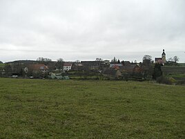
Hohendorf seen from the south (November 2013)
|
|
Hohendorf is a district of the city of Bürgel in the Saale-Holzland district in Thuringia .
geography
One of the two Wethau sources that unite in Petersberg rises near Hohendorf . The other arises from the inn to the gray billy goats in the corridor of Serba . The district of Hohendorf is stony and barren. The highest point is 367 m above sea level. Hohendorf is located north of Bürgel at the east end of the Tautenburger Forest in hilly terrain . The residents of the village have access to federal highway 7 via a local road .
history
The village was first mentioned in a document in 1145. The parishes of St. Georgenberg and Hohendorf are to be regarded as original mission parishes because of their size that is still visible today. Hohendorf belonged to the Wettin district office of Eisenberg , which was under the sovereignty of various Ernestine duchies due to several divisions in the course of its existence . In 1826 the place came with the southern part of the Eisenberg district office and the city of Eisenberg from the Duchy of Saxony-Gotha-Altenburg to the Duchy of Saxony-Altenburg . From 1920 he belonged to the Free State of Thuringia.
On July 1, 1950, the previously independent communities of Göritzberg and Nischwitz were incorporated.
The place was and is characterized by agriculture. The Hohendorf holiday home and the agriculture in this area determine the work in the country.
Web links
Individual evidence
- ^ Wolfgang Kahl : First mention of Thuringian towns and villages. A manual. 5th, improved and considerably enlarged edition. Rockstuhl, Bad Langensalza 2010, ISBN 978-3-86777-202-0 , p. 126.
- ↑ Rudolf Wolfram, Hans-Jochen Drafehn: The monastery church in Thalbürgel. Evangelische Verlagsanstalt, Berlin 1980, p. 9.
