Rodigast
|
Rodigast
community Burgel
Coordinates: 50 ° 56 ′ 7 ″ N , 11 ° 43 ′ 5 ″ E
|
|
|---|---|
| Height : | 250 m above sea level NN |
| Incorporation : | January 1, 1958 |
| Incorporated into: | Rodigast-Lucka |
| Postal code : | 07616 |
| Area code : | 036692 |
|
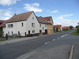
View of Rodigast
|
|
Rodigast is a district of the town of Bürgel in the Saale-Holzland district in Thuringia . The place is about ten kilometers east of Jena and about three kilometers west of Bürgel at about 250 m above sea level . The farmsteads of the square village are grouped around two village ponds in the middle.
geography
Neighboring places of Rodigast are Taupadel in the northwest, Nausnitz in the northeast, Lucka in the southeast and Kleinlöbichau in the southwest.
The Dorlberg (373 m above sea level ) is located about one kilometer west of Rodigast in the municipality . It is considered the easternmost witness mountain of the Horseshoe Ridge and is connected to the Jenzig .
The Löbnitzbach , a tributary of the tracks, has its source near the center of the village .
history
Rodigast was first mentioned in a document in 1355. In the historical topographical literature of Jena a . a. reports on the desert of Ober-Rodigast . The place name broadcast -gast , which is rare in Thuringia , identifies it as an Elbe Slavonic foundation. Before being incorporated into Bürgel, it formed a community with the neighboring town of Lucka since 1958 . Since the place does not have its own church, the practicing Christians are looked after by the parish in Taupadel.
traffic
The federal road 7 runs through Rodigast from Jena to Eisenberg in a west-east direction as well as the district road to Taupadel, Löberschütz in the north and the state road to Lucka, Schöngleina in the south.
