High clamp head
| High clamp head | ||
|---|---|---|
|
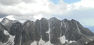
Klammerköpf from the northwest, the third peak from the right is the Hohe Klammerkopf |
||
| height | 3155 m above sea level A. | |
| location | Carinthia , Austria | |
| Mountains | Schobergruppe | |
| Dominance | 1.2 km → Kleiner Hornkopf | |
| Notch height | 225 m ↓ Klammerscharte | |
| Coordinates | 46 ° 57 '34 " N , 12 ° 45' 43" E | |
|
|
||
| Normal way | from Weißenkarsattel into the notch to the western Klammerkopf ( II + ) | |
The high clamp head , also the highest clamp head , is 3155 m above sea level. A. high mountain peaks of the Schober group in Carinthia .
location
The Hohe Klammerkopf is located in the south-eastern center of the Schober Group on the border between the communities of Heiligenblut am Großglockner in the north and Großkirchheim in the south. The border with East Tyrol is only 200 meters to the southwest. The High Klammerkopf is located between the Western Klammerkopf ( 3126 m above sea level ) in the southwest and the Eastern Klammerkopf ( 3153 m above sea level ) in the northeast. In the north of the Hohe Klammerkopf lies the Gößnitzkees along the north side of the Klammerköpfe to the Großer Hornkopf , to the southeast the Klammerkees used to be located west of the ridge to the Keeskopf . The closest alpine bases are the Adolf-Noßberger-Hütte in the southeast, the Lienzer Hütte in the southwest and the Elberfelder Hütte in the north.
Promotion opportunities
The normal route to the rarely used Hohe Klammerkopf leads initially marked from the Adolf-Noßberger-Hütte to the southwest to the Niedere Gradenscharte. At an altitude of around 2900 meters, you then cross the eastern ridge of the Keeskopf to the former Klammerkees and then climb up a notch between the western and the Hohe Klammerkopf. The Hohen Klammerkopf is finally reached after a short climb ( II + ). Alternatively, there is a notch between the high and the eastern staple head, which presents a similar difficulty for the climb. From the Elberfelder Hütte to the north there are two ascent variants over the Gößnitzkees. These are an ice channel (Klammerkopffrinne) located between the Hohem and the Eastern Klammerkopf or the northwestern rib between the West and the Hohem Klammerkopf.
Individual evidence
- ↑ Clem Clements, Jonathan de Ferranti, Eberhard Jurgalski , Mark Trengove: The 3000 m SUMMITS of AUSTRIA - 242 peaks with at least 150 m of prominence , October 2011, p. 16.
- ↑ Federal Office for Metrology and Surveying Austria: High bracket head on the Austrian Map online (Austrian map 1: 50,000) (according to the Alpine Club map : 3163 m )
literature
- Walter Mair: Alpine Club Leader Schobergruppe. Bergverlag Rudolf Rother: Munich 1972, ISBN 3-7633-1222-6 .
- Alpine Club Map 1: 25,000, sheet 41, Schobergruppe , ISBN 978-3-928777-12-4

