
Holstentorplatz


The Holstentorplatz is a square just outside of Lübeck's old town .
Location and shape
The Holstentorplatz, about 170 meters long and 70 meters wide, extends in an east-west direction. It begins as an extension of Holstenstrasse at the intersection with Obertrave and Untertrave and extends to the Puppenbrücke . Its western boundary is the intersection with Possehlstraße and the Wallhalbinsel leading Willy-Brandt-Allee formed. To the east, Wallstrasse joins Holstentorplatz directly at the Holstentor when coming from the south .
The interior of the elongated square is designed as a green area , the central path of which leads directly to the Holsten Gate at the eastern end. The outer areas are reserved for traffic and designed as a multi-lane road that is split up according to the directions of travel and completely surrounds the park.
history
The Holstentorplatz in its current shape and size was only created in the 1930s when the area around the Holstentor was completely redesigned.
Until 1851 the area was occupied by the ramparts built in the 17th century and the outer Holsten Gate from 1585, which was integrated into the ramparts and represented the only access to the city from the west. The older Holsten Gate preserved today was hidden behind these systems. When the first Lübeck train station was built in 1851, only the outer walls were removed, but the Holsten gates were not touched for the time being. It soon turned out, however, that the narrow passage of the medieval gate system represented a considerable hindrance for traffic between the city and the train station; In addition, an expansion of the railway system was quickly necessary, for which space had to be created.
From August 1853 to February 1854 the Outer Holsten Gate and the surrounding ramparts were removed. The remaining Holsten Gate was stripped of its function; From then on, traffic no longer flowed through its archway, but rather over newly laid streets that led around the building on both sides. From then on, the street Am Bahnhof led to the station building of the Lübeck-Büchener Railway . A small park was created on the newly created area between the train station and the Holstentor, which has now been exposed as a monument, in which a Bismarck monument by the artist Emil Hundrieser was erected in 1903 . The plan was to expand to a group of statues with Kaiser Wilhelm I and Helmuth von Moltke , but this never came about.
In 1901, the Senate and the citizenship decided to relocate the station 500 meters west of its narrow location at the time, where there was sufficient space for modern railway systems. At the same time, the architects Karl von Großheim , Karl Hinckeldeyn and Hermann von der Hude were commissioned to draw up an expert opinion on the future use of the area in front of the Holsten Gate that would become free. The architects recommended the construction of a monumental forum as a reception room in Lübeck. With this expert opinion as a basis, an architectural competition for the design of the terrain was held in 1906 . On September 22nd, 1906, chief construction director Johannes Baltzer announced the results, but none of the renovation plans were implemented. Even after the new station went into operation in 1908, the now unused old station building as well as the small park were preserved and the numerous subsequent plans to create a spacious square lined with representative buildings were never implemented, as there was no agreement on the desired aesthetic and urban development effect and the creative means to be used could be achieved.
After the First World War , the intentions to recreate the area around the Holsten Gate were suspended for a few years. In February 1926, by Oberbaurat was Friedrich Wilhelm Virck developed official plan presented, the traffic including tram passing forward only south at Holsten and create outside the city gate on the ample, the representative of an ensemble large buildings - office building , Holstentorhalle , Volkshaus and indoor swimming pool - surrounded should be. This plan was not carried out either.
- Holsten Gate Project (1930)

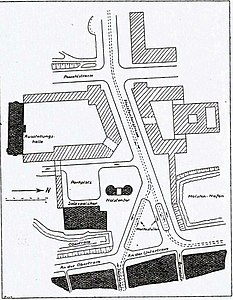
Site plan 1930

Draft 1
Draft 2

Draft 3


Based on the 1914 John Baltzer , the plan for the developing from Holsten project should remain the same until then, coming last proposal developed city building director Hans Pieper the Design 1 . The volume of traffic had increased until 1929 to such an extent that only the tram would drive through the Holstentor, the preservation of which, like the salt storage facility, was always undisputed - the rest of the traffic would drive around. However, the implementation of the design , which was unanimously approved by both the building authorities and the city's monument council in October 1929, provided for serious interventions in the building fabric . The entire traffic was now to be led around the Holsten Gate
Another problem, the bottleneck at the stops on the Holsten Bridge , had not yet been resolved. Erwin Barth and Leopold Thieme designed similar solutions to Pieper's in draft 2 .
When the Reichsbank, the last investor in the new building, withdrew its plans, Emil Scheufler suggested green spaces. The slope of the streets surrounding the square would be less, which would be widened on the Holstenbrücke. At the end of the square, both the square and the outer streets would be the same height. Pieper implemented this in draft 3 .
On September 26, 1933, Pieper submitted a new, completely different plan to the Senate. Now he proposed that the street and tram from the Puppenbrücke be led around the Holsten Gate, separated according to the directions of travel, and only reunited behind the building, immediately in front of the Holstenbrücke. The resulting open space was to be designed as a public green area, and the Holsten Gate was to be expanded into a museum. The Senate accepted this draft. After it was certain that the Reich Ministry of Finance was willing to support the project with grants, work began in January 1934. The old station building was removed and the new streets and park laid out. On October 5th, the square, which was named Holstentorplatz , was opened to the public.
Just three and a half years later, the name was changed to Adolf-Hitler-Platz . The Third Reich also appropriated the square with the historic city gate for its own purposes in other respects : between 1936 and 1939, there were several marches in the form of National Socialist solstice celebrations , consecration hours and other celebrations.
After the Second World War the name was changed back to Holstentorplatz; the green area gave way to a potato field , but was restored in 1948. In 1949 two statues of cast-iron reclining lions, which had flanked the entrance of the Hotel Stadt Hamburg am Klingenberg until it was destroyed in the air raid on Palm Sunday 1942 , found a new place on either side of the entrance to the park. With this, the Holstentorplatz had, with the exception of minor changes in detail, received the shape it still has today.
Buildings
- Holstentorplatz 2 , Reichsbank building built by Reichsbank building director Heinrich Wolff from 1934–1936
- Holstentorplatz 9 , Holstentor . The city gate in the brick Gothic style was completed in 1477
- Two lion statues at the eastern entrance to the park. The life-size figures made in cast iron by Christian Daniel Rauch in the middle of the 19th century were placed there in 1949
- The kiosk from the 1950s with a hexagonal floor plan
literature
- Jonas Geist : Attempt to mentally raise the Holsten Gate to Lübeck a little (= Wagenbach's pocket library 12). Verlag Klaus Wagenbach, Berlin 1976, ISBN 3-8031-2012-8 .
- Max Hoffmann: The streets of the city of Lübeck. In: Journal of the Association for Lübeck History and Archeology. Jg. 11, 1909, ISSN 0083-5609 , pp. 215-292 (also special print: 1909).
Individual evidence
- ↑ The Holstentor and the redesign of the Holstentorplatz. In: Lübeckische Blätter , No. 20, edition of May 18, 1930, pp. 318–321.
- ^ Proposal to redesign Holstenstrasse. In: Lübeckische Blätter , No. 29, edition of July 20, 1930, pp. 476–477.
Web links
Coordinates: 53 ° 51 ′ 58.6 " N , 10 ° 40 ′ 42.5" E