Hombach (Strunde)
| Hombach | ||
|
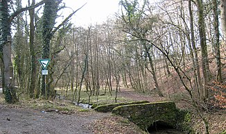
Bridge over the Hombach in the lower reaches |
||
| Data | ||
| Water code | Parameter error | |
| location |
Bergische plateaus
|
|
| River system | Rhine | |
| Drain over | Strunde → Rhine → North Sea | |
| source | near Kierdorf 50 ° 59 ′ 11 ″ N , 7 ° 11 ′ 5 ″ E |
|
| Source height | approx. 224 m above sea level NHN | |
| muzzle | at Gut Schiff in the Strunde coordinates: 51 ° 0 '0 " N , 7 ° 10' 13" E 51 ° 0 '0 " N , 7 ° 10' 13" E |
|
| Mouth height | approx. 135 m above sea level NHN | |
| Height difference | approx. 89 m | |
| Bottom slope | approx. 37 ‰ | |
| length | approx. 2.4 km | |
| Catchment area | 1.517 km² | |
| Big cities | Bergisch Gladbach | |
The Hombach (also incorrectly called Hambach in some directories) is a 2.4 km long, southern and left tributary of the Strunde in the area of the district town of Bergisch Gladbach in the North Rhine-Westphalian Rheinisch-Bergische Kreis .
geography
course
The main course of the Hombach rises at an altitude of about 224 m above sea level. NHN in a meadow south of the Kierdorf residential area . A tributary, also called Hombach, rises at an altitude of about 241 m above sea level. NHN in Herkenrath on Asselbroner Weg.
The stream initially flows in a southerly direction past Oberhombach and Unterhombach through the Hombachtal nature reserve . In the vicinity of Gut Schiff it finally flows out at an altitude of 135 m above sea level. NHN from the left into the street.
Catchment area
The catchment area of the Hombach lies in the Paffrath Kalksenke natural area and is drained into the North Sea via the Strunde and Rhine .
It borders
- in the north to that of the Asselborner Bach stream ,
- in the south to that of the Lerbach , also a tributary of the Strunde, and
- to that of the Volbach , a tributary of the Sülz ,
- otherwise the receiving strunde.
The catchment area consists mainly of forest and meadows.
Tributaries
The Hombach has no named tributaries.
Hombachtal nature reserve
The Hombachtal nature reserve extends from the source of a tributary of the Hombach at Breite to the lower reaches.
Individual evidence
- ^ Ewald Glässer: Geographical land survey: The natural space units on sheet 122/123 Cologne / Aachen. Federal Institute for Regional Studies, Bad Godesberg 1978. → Online map (PDF; 8.7 MB)
- ↑ a b c d Specialized information system ELWAS, Ministry for Climate Protection, Environment, Agriculture, Nature and Consumer Protection NRW ( information )
