Hornberg (Frankenhöhe)
| Hornberg | ||
|---|---|---|
|
Area on the Hornberg |
||
| height | 554 m above sea level NHN | |
| location |
Swiss franc amount
|
|
| Mountains | Swiss franc amount | |
| Dominance | 29.6 km → Hesselberg | |
| Notch height | 82 m ↓ Sulzach / Wieseth watershed near Burk | |
| Coordinates | 49 ° 13 '28 " N , 10 ° 10' 10" E | |
|
|
||
| Type | Layered plateau | |
| rock | upper middle keuper | |
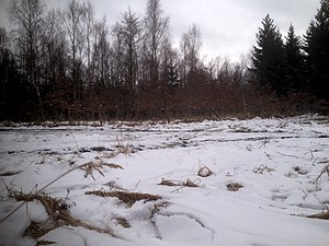
The Hornberg is 554 m above sea level. NN the highest elevation in Bavaria and Baden-Wuerttemberg located Frankenhöhe and is within the more broadly Crailsheim Hardt called sub natural area .
The wooded hilltop of the Hornberg rises in the forest area "Forlwald" in the area of the community Schnelldorf in the Bavarian district of Ansbach about 90-100 m above the western foreland of the Frankenhöhe around Gailroth and about 70 m above the flat tributary valleys of the Waldhauser Mühlbach and the Schwarzenbach near Wildenholz , which drain east of the step edge to the upper Wörnitz .
The highest point of the Hornberg, surrounded by a triangular plateau in the sandstone Keuper of over 20 hectares, tapering to the west-southwest , is about 1.5 km north of the "Schnelldorf" junction on the A 6 , about 3 km north of the center of the Schnelldorf community itself, just as far east of the associated Gailroth and about 2.3 km west of Wildenholz, a northeastern part of the municipality.
The slope of the mountain to the northwest drops quite steeply to the valley of the Seebach near Theuerbronn, which starts a little north of the high plateau and moves west towards the Jagst . The southern slope to the valley of the Schnelldorfer Heckelbach , which also reaches the Wörnitz via the Ampfrach, is also steep ; in its western part is this valley already from (on the Jagst or even underground on the Buhler ) Western- Rhine draining stallion fields Hengstbach tapped beyond which km here in 1.5 removal in the south-southwest at 547 m above sea level. NN is the second highest mountain of the Frankenhöhe, the Birkenberg . To the north and south-east of the Hornberg, on the other hand, its plateau continues beyond rather flat terrain cuttings as a more or less narrow, often less than 10 m lower and quite flat mountain ridge: over the Eichenschlag ( 546 m above sea level ) to the Grüber Ranken ( 546 m) above sea level ) in the north or over a likewise 546 m above sea level. NN reaching hilltop south-west of Wildenholz to the Schloßberg ( 534 m above sea level ) between Wildenholz and Oberampfrach in the south, at the feet of which cross a pass of the Frankenhöhe railway, motorway and country road in a bundle from the Ampfrach valley to the Wörnitz valley.
The Hornberg can only be reached on forest paths .
literature
- Official topographic map 1: 25,000, sheet ATK25-H05 Schillingsfürst
Individual evidence
- ↑ Height after labeling at a height measuring point on the background layer Topographic map from: BayernAtlas of the Bavarian State Government ( information )
- ↑ Wolf-Dieter Sick : Geographical land survey: The natural space units on sheet 162 Rothenburg o. D. Deaf. Federal Institute for Regional Studies, Bad Godesberg 1962. → Online map (PDF; 4.7 MB)
- ↑ Geology based on the geological map of Bavaria 1: 500,000 layer (only faded in when the scale is very large) on: Bavaria Atlas of the Bavarian State Government ( notes )

