Huai He
|
Huai He lower reaches: Feihuang He |
||
|
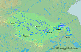
The Huai He river basin between the Yellow River (Huang He) in the north and the Yangtze River (Chang Jiang) in the south |
||
| Data | ||
| location | Henan , Anhui , Jiangsu ( PR China ) | |
| River system | Huai He | |
| Headwaters | in the Tongbai Mountains 32 ° 23 ′ 17 ″ N , 113 ° 17 ′ 5 ″ E |
|
| muzzle | as Feihuang He in Jiangsu into the Yellow Sea Coordinates: 34 ° 15 ′ 19 ″ N , 120 ° 16 ′ 55 ″ E 34 ° 15 ′ 19 ″ N , 120 ° 16 ′ 55 ″ E
|
|
| length | 1078 km (including Feihuang He) | |
| Reservoirs flowed through | Hongze Lake | |
The Huai He or Huai River ( Chinese 淮河 , Pinyin Huái Hé , W.-G. Huai Ho , obsolete after Post Hwai Ho ) is a 1078 km long river in China . Its northern section is also called Feihuang He ( 廢 黃河 / 废 黄河 , Fèihuáng Hé - "abandoned yellow river").
The river has its source in the Chinese province of Henan in the Tongbai Mountains . From there, its water flows in an easterly direction through the provinces of Anhui and Jiangsu . In the latter, its water passes the cities of Huainan and Bengbu and flows through the Hongze Lake ( Hungtse Lake ), from which there is a canal connection to the Yangtze River . A little further to the east, the flowing water - now called Feihuang - flows through the directly neighboring cities of Huai'an and Suqian , after which it reaches the Yellow Sea , a marginal sea of the Pacific .
The Huai was dammed into a large reservoir by the Fushan Dam , which broke in 516.
The Huai He is often considered the border between northern China and southern China .
literature
- Otto Franzius : The regulation of the Hwai Ho, the Kaiserkanals etc. , in: Die Bautechnik 11 (September 19, 1933), Issue 40, pp. 568-578
