Humber (North Sea)
| Humber | ||
|
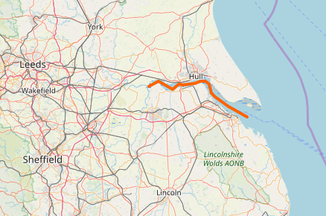
Location of the Humber in Northern England |
||
| Data | ||
| location | England | |
| River system | Humber | |
| origin | Confluence of the Ouse and Trent at Alkborough 53 ° 42 ′ 1 ″ N , 0 ° 41 ′ 28 ″ W |
|
| muzzle | in the North Sea coordinates: 53 ° 31 ′ 22 " N , 0 ° 8 ′ 22" E 53 ° 31 ′ 22 " N , 0 ° 8 ′ 22" E
|
|
| length | 62 km | |
| Catchment area | 24,240 km² | |
|
Humber Bridge west of Hull |
||
The Humber [ ˈhʌmbə ] is a long estuary on the east coast of England . It arises from the union of the rivers Ouse and Trent , takes in other tributaries along the way and flows into the North Sea . Overall, it is 62 kilometers long and forms part of the border between the East Riding of Yorkshire on the north bank and North Lincolnshire and North East Lincolnshire on the south bank. Although often referred to as the River Humber , the Humber is not a river, but a particularly elongated estuary because it is subject to the tides and has brackish water .
course
The Humber passes shortly below its point of origin (“Trent Falls”) the Market-Weighton Canal , which meets the estuary from the north. The Ancholme River flows into the basin from the south. Then he passes the Humber Bridge and the opposing cities of Kingston upon Hull (north) and Barton-upon-Humber (south). The Hull empties after he has passed through the same city, here in the estuary. Finally, the Humber reaches the North Sea at Cleethorpes and the southern tip of the Spurn Spit. Ports along the Humber are Kingston upon Hull, Grimsby , Immingham , New Holland and Killingholme .
history
At the time of the last ice age, when the sea level was still far below today's level, the Humber was a long freshwater river, which mostly crossed the still dry bed of the North Sea. In the Anglo-Saxon period, the Humber represented a distinctive border by separating Northumbria from the kingdoms to the south. The name Northumbria means located north of the Humber .
At the beginning of the First World War in 1914, two strong fortifications, the Haile Sand Fort and the Bull Sands Fort , began to be built to protect the estuary ; however, they were not completed until the end of the war. In World War II they were preserved as a deterrent and regularly subjected to enemy air attacks on themselves.
Today the Humber is the border between East Riding of Yorkshire in the north and North / North East Lincolnshire in the south. The three areas mentioned were previously combined to form the county of Humberside between 1974 and 1996 . At the level of the regions used for statistical purposes, the whole area along the Humbers is part of the Yorkshire and the Humber region .
Crossings
Road bridge
The only structure that crosses the Humber is the Humber Bridge , which was the longest suspension bridge in the world when it opened in 1981. It crosses the main A15 road with separate footpaths and cycle paths.
Wading
On August 22, 2005, Graham Boanas from Hull forged the Humber in just under four hours. The wading stretch at the level of the village of Whitton, just below the source of the Humber, is about 1.6 km long. The schedule had to be adapted exactly to the tidal range - in the fairway the water level was only so low for a few minutes that the more than two meter tall Boanas could keep his head and shoulders above water. The event is considered the first Humber crossing since the Roman times and served the fundraising for the charity DEBRA .
Individual evidence
- ^ Humber crossing after 1,000 years . In: BBC News Online . British Broadcasting Corporation . August 22, 2005. Retrieved August 15, 2018.
Web links
- Official website of the Humber Bridge (English)
- Environmental History (English)

