Huttaler counterbalance
The Huttaler Widerwaage even Hutthaler Wider scale called, is a building of the Upper Harz Water Regale east of the district of Goslar lies Clausthal-Zellerfeld in neighboring unincorporated territory resin of the district Goettingen in Lower Saxony .
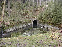
The structure is able to supply water from the Huttal to the Hirschler pond when the water level is low and, conversely, to relieve it of excess water when the water level is high. Like all buildings in the Upper Harz Water Regale includes the Huttaler Widerwaage since 2010 to UNESCO - World Heritage Site .
Geographical location
The Huttaler Widerwaage is located in the Upper Harz in the Harz Nature Park . It is located south-east of Clausthal-Zellerfeld around 550 m east- south- east of the Innerste jump and around 500 m south of the federal road 242 at the Huttaler Graben at around 605 m above sea level. NHN .
function
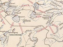
As resistance level in the area of Upper Harz Water Regale is called a small basin or a small damming. This basin is dammed here by a wooden weir structure, a so-called failure . It is connected to the Hirschler pond on the other side of the ridge through the Huttaler watercourse and communicates with it. From the Huttaler Graben, water from the Schwarzenberg and the Polsterberger Hubhaus is fed to the counterweigher . If the weir is dammed up, the water is forwarded through the Huttaler watercourse to the Hirschler pond. There it could be used for the power water supply of the very productive pit Caroline and pit Dorothea .
In the event of high water, the weir boards can be removed. Then the flow gradient is reversed and water from the Hirschler pond flows through the Huttaler watercourse and through the Huttaler Widerwaage into the Huttal and then on towards Söse . As a result, the flood situation in Clausthal could be defused.
history
The Huttaler Widerwaage arose from the necessity that the two most profitable and highest located mines Dorothea and Carolina needed more water for the turning and artificial wheels for ore extraction and water lifting. Through the construction of the Widerwaage in the years 1763 to 1776 and the expansion of the catchment area up to around 1860 it was possible to get water from the Sösegar over the Kautztaler Graben, the Alte Polsterberger Wasserlauf, the Schwarzenberger Graben and the Grüneberger Graben, over the Huttaler Wasserlauf, to feed the Hirschler pond. Due to the larger water supply, the two sweeping wheels of the shafts could now be built in their immediate vicinity.
The Huttaler watercourse was opened in 1767. At first it had a bottom slope to the Hirschler pond and could only lead the water in one direction, namely to the Hirschler pond. Around 1850, the need to improve flood protection for the mountain town of Clausthal was seen, and now the Huttal watercourse was converted to allow large amounts of water to be diverted in the opposite direction from the Hirschler pond into the Söseggebiet. For this purpose, the tunnel cross-section was widened considerably to a width of around 2.0 m, and hydraulically disruptive curves were straightened. The bottom slope was reversed. To do this, the watercourse in the Huttal area had to be deepened by around 1.0 m. Today's relatively elaborately designed building also dates from this time.
In 1801 the Polsterberger Hubkunst was created. Thanks to the art of lifting, water could be pumped from the dam ditch into the Huttaler Widerwaage system and flow into the Hirschler pond.
The old Polsterberg watercourse from the years 1681 to 1690 was replaced by the Schwarzenberg watercourse in 1815 and discarded.
Legends
In the Upper Harz , other abilities of the Huttaler Widerwaage were ascribed for a long time, such as further communication via a 4 km long trench and watercourse tour with the Jägersbleeker pond and the miraculous storage of another 100,000 m³ of water. However, this theory can be refuted solely on the basis of the geometric dimensions. It still circulates in all kinds of literature.
hike
The Harzer Hexenstieg leads past the Huttaler Widerwaage . The building is included as no. 128 in the system of stamping points of the Harz hiking pin.
See also
literature
- Alfred Dumreicher: Entire overview of the water management of the north-western Upper Harz . Oberharzer Geschichts- und Museumsverein eV, Clausthal-Zellerfeld 2000, ISBN 3-9806619-2-X (new edition of the original from 1868).
- Martin Schmidt : The water management of the Upper Harz mining (= publication series of the Frontinus Society. Issue 13) . 3rd supplemented edition. Harzwasserwerke, Hildesheim 2002, ISBN 3-00-009609-4 .
- Justus Teicke: The Huttaler counterbalance and its function. In: General Harz-Berg-Kalender for the year 2009. ISSN 1867-5395 , pp. 80–83.
Web links
Individual evidence
- ↑ Map services of the Federal Agency for Nature Conservation ( information )
- ↑ Harzer Wanderadel: stamp point 128 / Huttaler Widerwaage , on harzer-wandernadel.de
Coordinates: 51 ° 47 ′ 8.7 ″ N , 10 ° 22 ′ 37.5 ″ E


