Inwood Hill Park


The Inwood Hill Park is a park at the northern end of Manhattan in New York City . The land on which the park is located belongs to the city; it is supervised by the New York City Department of Parks and Recreation . The park is on the Hudson River , from Dyckman Street to the northern tip, where it ends at Spuyten Duyvil Creek . To the south, Dyckman Street separates Inwood Hill Park from Fort Tryon Park .
description
From 1915 the city bought the land that is now part of the park. The park was officially opened on May 8, 1926. After the last acquisitions in the early 1940s, the park now covers an area of almost 80 hectares . The park is very hilly and mostly forested, the forest is the largest and last natural forest on Manhattan. Like many other parks in New York City, there are large areas here that are still in their natural state and have not been created. Numerous paths lead through the park, a lawn, playgrounds, basketball and baseball fields are mainly located on the northern side. The park is heavily frequented by residents of the surrounding residential areas.
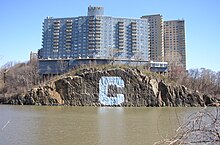
The Henry Hudson Parkway runs parallel to the Hudson River through the park, between the park and the Hudson River run the tracks of the former Hudson River Railroad , today Amtrak Empire Connection , which lead to Albany . On the other side of Spuyten Duyvil Creek you can see a blue “C” about 30 meters high on a rock. The Columbia University logo has been there for about 50 years.
history
At the place where the park is today, the Dutch navigator Peter Minuit exchanged the island of Manhattan in 1626 for 60 Dutch guilders from the Lenape , the indigenous people of this area. Minuit named the island New Amsterdam . At the presumed handover point, a stone, the Shorakkopoch Rock , with a plaque commemorates the event.
Flora and fauna
The park is home to the last salt marshes on Manhattan. These and the open spaces attract large numbers of water birds such as ducks , snow geese and ring-billed gulls that live here all year round. Herons and cormorants can also be found here in summer . Blue jays , red cardinals and some species of birds of prey live in the wooded areas . In the summer of 2002 a project was attempted to resettle the bald eagle in Manhattan. Inwood Hill Nature Center is located near the park entrance on 218th Street . It offers an interactive exhibition and opportunities to observe the flora and fauna of the park. The Nature Center had to close in 2012 after damage from Hurricane Sandy and will reopen in 2019.
geology
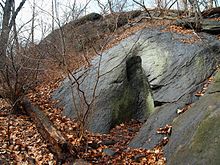
Many different exposed geological structures can be seen in Inwood Hill Park. In some places you can find marble, slate and limestone outcrops . The whole area is located on the seismologically active Dyckman Street Fault , which runs parallel to the southern park boundary and triggered a magnitude 2 earthquake in 1989. The park also has the largest glacier pot in New York City.
Web links
Individual evidence
- ^ A b c Inwood Hill Park, New York City Department of Parks and Recreation
- ↑ Kenneth T. Jackson (Ed.): New Amsterdam. In: The Encyclopedia of the City of New York. Yale University Press, New Haven 1995.
- ↑ Bald Eagles in Inwood Hill Park
- ↑ Washington Heights & Inwood online: Inwood Hill Park ( Memento of September 2, 2010 in the Internet Archive )
- ^ A tribute to Inwood Hill Park, the location of Manhattan's last natural forest. boweryboyshistory.com from April 13, 2018.
Coordinates: 40 ° 52 ′ 20 " N , 73 ° 55 ′ 33" W.


