Irind
|
Irind Իրինդ |
||
| State : |
|
|
| Province : | Aragazotn | |
| Coordinates : | 40 ° 23 ' N , 43 ° 59' E | |
| Height : | 1884 m | |
| Residents : | 943 (2012) | |
| Time zone : | UTC + 4 | |
| Community type: | Rural community | |
|
|
||
Irind ( Armenian Իրինդ ) is a village and a rural community ( hamaynkner ) in the northern Armenian province of Aragazotn with officially 943 inhabitants in 2012. In the center of the village, the ruins of an unusual polygonal church with seven star-shaped conches , which according to popular belief are preserved in the 7th century is dated.
location
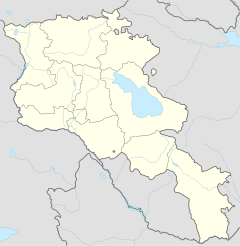
Irind is located at an altitude of 1884 meters on the western foothills of Mount Aragaz . From the M1 expressway between Yerevan and Gyumri , a road branches off 18 kilometers north of Arutsch and five kilometers south of Talin to the village of Katnagbhyur. From the town center, one kilometer east of the M1, a good asphalt road leads to the eastern edge of the town, where it turns north at the junction of a side road coming from Davtashen and after three kilometers you reach Irind.
The plain between the valley of the Achurjan River on the Turkish border, which is 30 kilometers from Irind, and the Aragaz is a flat, undulating treeless grassland, which is mainly used as pasture for cattle.
Townscape

In the 2001 census, the official population was 840. According to official statistics, Irind had 943 inhabitants in January 2012. Like the neighboring villages, Irind lies in a depression through which the watercourses from nearby springs flow. The farmhouses, cattle sheds and haystacks are surrounded by gardens where apple and cherry trees flourish and vegetables are grown.
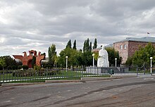
The place was founded in 1921 by Armenians who had fled the area in what is now eastern Turkey, which the Armenians called Western Armenia, because of the 1915 genocide . 46 of the arrivals came from the city of Sason and 33 from Mus . A monument in the central square reminds of the circumstances of the foundation, showing two huge eagles made of pink tufa slabs, which are connected to one another via an archway. The double-headed eagle has been a dynastic symbol of Armenian Christianity since the 4th century.
The road coming from the south ends at this place; the compact town center with the church ruins is to the east of it. The urban space, which appears oversized for an agrarian village, was laid out as a park next to a large town hall building. The park, street and town hall are thanks to Andranik Markarjan , who was Prime Minister of Armenia from 2000 until his death in 2007 and whose parents from Sason lived here. In 2010, in honor of Markarjan, a larger-than-life white marble statue (symbolizing purity) was erected next to the eagle monument.
An ecological reforestation program donated around 4,000 trees to the site between 2007 and 2010, 3200 of which are fruit trees planted in private gardens and 800 other trees that are supposed to provide shade on public areas.
church
Origin of the radial domed buildings
The oldest and best-known Armenian central dome building with four conches ( tetrakonchos ) is the Zvartnots Cathedral , which according to historical and epigraphic sources is usually dated to the middle of the 7th century and of which only a few rows of stones and columns stand upright. The dome spanned the entire central space and was supported by columns and half-columns on the four inner wall corners. This type of tetrakochos with a circular handle was imitated several times, including in the 10th century in the round church of Bana . In another, independently developed central building construction, a smaller dome rests on four free-standing pillars arranged in a square, with the distance between pillars and walls being bridged by belt arches . The model of this development is the new building of the Etschmiadzin Cathedral (Etschmiadzin II), which was built around 485 , followed by the first phase of the now completely destroyed Theodoros Church in Bagaran , which is dated 624–631.
The more complex polygonal ground plan with six or eight apses can be interpreted as a conceptual further development of the Zvartnots Cathedral, which in turn was based on tetraconch predecessors in the Mediterranean region and in Syria. However, a chronological sequence of the increasing number of apses cannot be documented, provided that reliable dates are available at all. In 10./11. In the 19th century, central buildings appeared in Armenian architecture without the use of four, six and eight conches.
In the 7th century, six and eight-cone systems were rare in Armenia; they were much more common in Byzantine architecture . According to Jean-Michel Thierry, the only two known eight- conch complexes of the 7th century in Armenia are the Zoravar church at Jeghward (661–685) and - with the typological difference of the western conche that has become the entrance - the church of Irind. Radiant multi-conical churches from the 10th century onwards are, for example, the Church of St. Gregory ( Surb Grigor ) in Ani with six conches and the Erlöserkirche there (dated 1036) with eight conches. Christina Maranci also dates Irind to the 10th century, while Jean-Michel Thierry assumes that it is at the end of the 7th century due to its architectural affinity with Zvartnots and Jeghegis.
Design
In contrast to the closest related church of Jeghward with its almost symmetrical octagonal floor plan, the church of Irind has seven equally large horseshoe-shaped conches (heptaconchos), which are grouped radially around a center. Only in the west, instead of another conche, is a rectangular room, which is entered first from the entrance. The entrance hall was covered with a cross vault without ribs. A second entrance was reconstructed in the south. In addition, there are almost square side rooms, which are arranged on both sides of the east cone and are entered from the two adjacent cones. The ancillary rooms are located within a rectangular outer wall that protrudes from the idealized round basic shape in the east.
The outer walls are structured by wide triangular niches between the conches. This results in a star shape in the ground plan, the symmetrical structure of which is interrupted by the rectangular bulges in the east and west. Josef Strzygowski counted this type in 1918 to the "eight passports with triangular slits". The outer edges of the cones are emphasized by doubled half-columns with cubic capitals , between which arches over the niches close to form a semicircle. Here, protruding blind arches alternate on the straight wall surfaces with arches lying in the wall plane above the niches.
Inside, simple half-columns on the wall corners of the conches support belt arches, between which pendants lead to the base of the drum . The wall fields of the inside round and outside octagonal drum are broken up by large arched windows. Their arrangement corresponds to the windows of the cone walls below. V-shaped niches cut into the drum corners, as they are also found in St. John's Church ( Surb Hovanes ) in Mastara (north of Talin, mid-6th or mid-7th century) and the St. George's Church ( Surb Geworg ) in Garnahovit (near Artik , 7th century) . Century). The dome, which was missing after an earthquake since the 19th century at the latest, had a diameter of 8.35 meters.
Photographs from the beginning of the 20th century and from the 1990s show the church in a similar state of preservation as a field of rubble with the upright north wall and a wall segment of the drum that contains two window openings. After the turn of the millennium, extensive restorations began towards an approximate reconstruction using new stone slabs. In 2013, the outer walls were bricked up to the edge of the eaves and some layers of the drum. The walls consist - typical for Eastern Armenia - of carefully hewn pink tuff plates and a core of cast masonry .
literature
- Burchard Brentjes , Stepan Mnazakanjan, Nona Stepanjan: Art of the Middle Ages in Armenia. Union Verlag (VOB), Berlin 1981, p. 69
- Patrick Donabédian: Documentation of the art places . In: Jean-Michel Thierry: Armenian Art. Herder, Freiburg / B. 1988, p. 551, ISBN 3-451-21141-6
- Christina Maranci: Medieval Armenian Architecture. Construction of Race and Nation. (Hebrew University Armenian Studies 2) Peeters, Leuven u. a. 2001
- Josef Strzygowski : The architecture of the Armenians and Europe. Volume 1. Kunstverlag Anton Schroll, Vienna 1918, pp. 131-134 ( online at Internet Archive )
Web links
- Rick Ney: Aragatsotn March . Tour Armenia, 2008, p. 82f
- Irind Church. Armeniapedia
Individual evidence
- ^ RA 2001 Population and Housing Census Results . armstat.am
- ^ RA Aragatsotn March. armstat.am, 2012
- ↑ Monument of Andranik Margaryan erected in Irind . panorama.am, June 12, 2010
- ^ Armenia Tree Project . armeniatree.org
- ^ Adrineh Der-Boghossian: ATP adds to Irind's community improvement . ( Memento of October 5, 2011 in the Internet Archive ) The Armenian Reporter, July 13, 2010
- ↑ Stepan Mnazakanjan: Architecture . In: Burchard Brentjes u. a., p. 66f; 621–631 dated in Christina Maranci, p. 102
- ↑ W. Eugene smallholder: Zvart'nots and the Origins of Christian Architecture in Armenia . In: The Art Bulletin , Vol. 54, No. 3. College Art Association, September 1972, pp. 245-262, here p. 256
- ↑ Christina Maranci, pp. 107, 109
- ↑ Jean-Michel Thierry, p. 77
- ↑ Christina Maranci, p. 109
- ↑ Josef Strzygowski, p. 131
- ↑ Stepan Mnazakanjan: Architecture. In: Burchard Brentjes u. a., p. 64
- ^ Patrick Donabédian: Documentation of the art places . In: Jean-Michel Thierry, p. 563


