
Isar plan
The Isar Plan is a completed project for the renaturation of the Isar in Munich . From 2000 to 2011, the river landscape of the Isar in the eight kilometer long section in the area between Großhesseloher Brücke and the Deutsches Museum was designed with great effort under the motto "New Life for the Isar" . In the course of the measure, the flood protection was improved, the river banks made more natural on both sides and the inner-city recreational value was noticeably increased.

Starting position
The Isar runs through the city of Munich over a length of almost 14 km between the Großhesselohe weir in the south and the Oberföhringer weir in the north. Until the beginning of the 19th century, the Isar meandered along a river bed several hundred meters wide east of the city. Gravel banks, islands, branched river arms and brooks shaped the landscape. In the middle of the 19th century, the Isar represented an intact alpine river landscape in the Munich urban area.
The tamed river
At the beginning of the 19th century, work began on fortifying the banks and partially channeling the river. Weirs, embankment walls and a narrowed river bed were intended to contain the risk of flooding for the neighboring districts. Further regulatory measures were necessary when the first hydropower plants went online at the beginning of the 20th century. The systematic expansion of the river bed from the middle of the 19th century and the use of hydropower in the power stations of the Isar canal , which was built at the beginning of the 20th century, gave Munich a strong boost. The Isar then flowed in a fixed, linear bed about 150 m wide, bordered by flood meadows and flood dikes. The consequences were increased flow rates and considerable disadvantages for plants and animals. The river was tamed, wedged into quay walls on both sides, the people of Munich valued the technical achievements. They could grow close to the river. But the Isar lacked space to expand. This had negative consequences during floods: the river overflowed its banks earlier and more often, there were no compensation areas on the banks, and during floods there was no buffer for the water masses.
First plans
The first plans to liberate the Isar from its corset of fortified banks in some sections and to renaturalize it came about in the course of the environmental movement in the 1980s. The straightened and concreted river stretches no longer corresponded to the ecological ideas. In 1988 the Munich city council decided to redesign the Isar in a natural way. The citizens, associations, ministries and political bodies were involved in the preparation for this project.
Joint effort between city and country
In 1995, the state capital of Munich and the Free State of Bavaria set up the Isar Plan working group. Representatives of the state water management authority in Munich as well as the building department, the planning department and the department for health and environment of the state capital Munich were involved. The target was: better protection against floods, more space and closeness to nature for the river landscape and higher quality for leisure and relaxation. The project includes the 8 km long river stretch from the Großhesseloher Wehr to the Deutsches Museum. The Isar Plan became a joint project between the Free State of Bavaria and the state capital. The Free State, represented by the Munich Water Management Authority, was in charge. With the decision of principle of the Munich city council of February 23, 2000, the building department was entrusted with the building owner for the city.
- Six stations of the Isar renaturation

Thalkirchen bridge

.. via Flauchersteg

... Brudermühlbrücke
..to Willow Island
Small Isar at the Deutsches Museum


Nature by the river
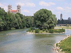
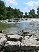
As part of the renaturation, the river bed was widened and the flood dikes were repaired. The stone banks have given way to flat, partly terraced, accessible banks. Sturgeon stones and groups of stones were built under the waterline. This created a variety of currents with high flow speeds alternating with flow shadows as resting zones for the fish. In addition, dead wood was installed in suitable places. Gravel areas and natural bank formations were created with many recreational opportunities and interesting visual links to the river. Adequate water supply and quality improved the habitat for fauna and flora. The Isar can meander again, shifting its banks and gravel with every flood. Isar-typical plant and animal species have the chance to settle again.
Flood protection
The flood dikes play a key role in protecting against flooding. It is important how much water drains off. At the Isar level in Munich, the maximum discharge is 1,100 m³ / s. With this drainage, the freeboard must be at least 1.0 m. In order to achieve better flood protection , the river bed was generously widened as part of the Isar plan, and the dike tops were raised slightly. In order to protect the valuable trees on both sides of the dykes, earth concrete walls or front oaks were installed. Flat banks, upstream gravel banks and gravel islands made of stone blocks were created. The basins and flat ramps in between give a natural impression. So that the river does not dig itself into the green areas during floods and when meandering, so-called dormant safety devices made of armourstones were installed in the flat flood bed. In the last construction phase up to the Deutsches Museum, the river bed of the Isar was widened. The east bank was fundamentally redesigned, the situation on the west bank was retained. In the course of this widening of the river bed, which was necessary for flood protection, the old bank protection was removed and gravel banks and gravel islands were newly created. The Isar Plan passed its first major test during the construction phase in August 2005, when an almost centenary flood caused the river to swell up to the top of the dike. The first major flood after the renaturation was completed was at the beginning of June 2013. The Isar was able to cope with the water masses well. "The bathtub has been made bigger," said a spokesman for the Munich water management authority; the renatured river bed could absorb more water. After the flood had subsided, it became clear that the Isar had changed the course of the river in some places, which, however, had been taken into account by the hydraulic engineers.
- Near-natural river engineering
Natural stone shore
Larch wood bridge

Natural stone terrace
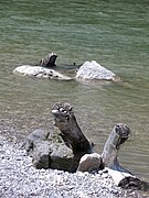
Dead wood and stones

Meandering river course

Eco base ramp


Clean water
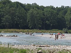
From the beginning, the cleanliness of the Isar water was also the aim of the Isar plan. In an effort to implement the Water Framework Directive of the European Union was a key aspect to obtain a hygienically clean Isar. This was only possible by improving the wastewater situation in the Isar upper reaches. All municipal sewage treatment plants above Munich on the Isar and Loisach, but also the Munich sewage treatment plants, have been equipped with bacteriological cleaning stages using UV radiation. The minimum water flow in the Isar is also advantageous for the water quality and the ecological conditions in the river. As part of the Isar plan, the Munich municipal utilities contractually agreed to an annual average water flow of at least 12 m³ / s instead of the previous 5 m³ / s in the diversion section of the Isar. The bathing water quality of the Isar in the catchment area of Munich is unique in all of Europe. The environmental department of the City of Munich has issued a bathing permit for most of the renatured Isar, namely for the area between Flaucher and the southern city limits. Swimming is explicitly allowed between Wittelsbacherbrücke and Reichenbachbrücke .
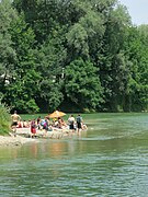
Leisure paradise
The Isar Plan has given Munich and the people of Munich a recreational area of high quality. The bank areas offer space for relaxation, sports and games. Smaller green areas are mowed regularly. Volleyball and soccer are played there. On sunny weekends, people from Munich flock to the Isar, they stroll along the banks and they camp and play on the gravel banks. The pillars of the Brudermühlbrücke are the working surface of young artists (groups) who, in cooperation with the city's cultural department, apply graffiti once or twice a year. Since June 2011, the Isar can be experienced along the entire route in its new diversity between Großhesseloher Wehr and the Deutsches Museum.
- Local recreation on the Isar

Terrace
Island fun

lunch break
Bike on the jetty
Isar, built-in stones

New pastures


Conflicts
The three project goals of flood protection, renaturation and recreational use could not always be agreed without problems. In addition, there were controversies about the model according to which the river landscape in the city should be developed. The landscape architects' competition for the section between the Braunau railway bridge and the Deutsches Museum resulted in two prize winners with radically different designs. The first prize winner, the Irene Burckhardt office, opted for an urban river. Concrete should be visible and shape the flow of the main river and a tributary. The aim was to make the design recognizable as a structural measure and the river as a human work. The runner-up, the Winfried Jerney office, took the wild river character on the Flaucher as a model and responded to the great appreciation of this landscape among the population. In the debate, his design was called natural . Citizens and the district committees were clearly in favor of realizing the second prize. After an extensive discussion in the years around 2004, the revised draft of the runner-up became the basis for implementation.
Renatured Isar
Since June 2011, the Isar between Großhesseloher Wehr and the Deutsches Museum can be experienced in its new, natural diversity. The pre-alpine wild river Isar shows its origin again today and does the most important task itself - it forms its river bed independently over time. In the last construction phase between Wittelsbacher Bridge and the Deutsches Museum, the river was divided into main and side arms. Between Wittelsbacherbrücke and Reichenbachbrücke a 1,500-square-foot covered with willow island, known originated willow island , a valuable habitat for many plant and animal species. The new branches offer excellent conditions for fish fauna and macrozoobenthos . Shallow water zones, gravel gap systems and flow-calmed areas offer valuable diverse habitats.
- Natural vegetation

100 years old


The new Isar
The Isar has become a near-natural river again, showing its alpine origins. The canalised river bed has largely disappeared, the banks are flattened and remodeled in a natural way. Gravel banks, shallow banks and small islands, shallow water zones and pools, rapids and calm water alternate. The trees on the Isar dikes have survived the years of construction work with large machines and are secure for the long term. In some areas the flat banks rise like terraces. The Isar can move freely again within the new, greatly expanded borders. More water can drain off by expanding and lowering the flood meadows, and the naturally formed river offers more living space for animals and plants.
The Isar Plan in numbers
| length | 8 kilometers |
|---|---|
| construction time | February 2000 to June 2011 |
| Excavation | 1.3 million tons of soil |
| Gravel movements | 290,000 m³ relocated |
| Base ramps | 24 pieces new and rebuilt |
| Armourstones | approx. 385 t installed |
| costs | 35 million euros |
Awards
In 2007, the German Association for Water Management, Wastewater and Waste eV (DWA) awarded the DWA Water Development Prize for the first time for exemplary measures for the conservation, natural design and development of water bodies in urban areas. The first - joint - award winners are the Munich Water Management Authority and the City of Munich for the Isar Plan project.
literature
- Ralf Sartori : The new Isar - renaturation, cultural opening and flow of ideas ... Volume I, Book & Media, Munich 2010, ISBN 978-3-86520-381-6 .
- Ralf Sartori: The new Isar - renaturation, cultural opening and flow of ideas ... Volume II, Book & Media, Munich 2011, ISBN 978-3-86520-390-8 .
- Peter Klimesch : Isarlust - Discoveries in Munich, The renatured Munich Isar. MünchenVerlag , Munich 2011, ISBN 978-3-937090-47-4 .
- Julia Düchs: When will it be beautiful again on the Isar? The renaturation of the Isar in Munich - About the understanding of nature in the big city. Münchner Ethnographische Schriften Volume 16. Herbert Utz Verlag 2014, ISBN 978-3-8316-4276-2
Web links
- glockenbacher.de photo series about the renovation phase
- TV report about the renaturation of the Isar
- Time lapse of the state capital Munich
Individual evidence
- ↑ Isar map from the Munich Water Management Authority, accessed on July 24, 2014
- ^ Isar map, background: From wild river to cultural river, accessed on July 24, 2014
- ↑ The Isar remains tame. In: Süddeutsche Zeitung. 3rd June 2013.
- ↑ Baden in the Isar. In: Süddeutsche Zeitung. November 25, 2011, accessed July 24, 2014.
- ↑ Düchs 2014, p. 37
- ↑ Düchs 2014, p. 38
- ↑ Düchs 2014, pp. 38–40
- ^ Isar plan, the final, accessed on July 24, 2014