
Jägerhaus (Schwarzenberg)
|
Hunter's House
City of Schwarzenberg / Erzgeb.
Coordinates: 50 ° 30 ′ 32 " N , 12 ° 42 ′ 54" E
|
|
|---|---|
| Residents : | 38 (May 9, 2011) |
 Jägerhaus and Ochsenkopf on sheet 222 of the Sächsische Meilenblätter from 1791
|
|
Jägerhaus is a group of houses belonging to Schwarzenberg in the Ore Mountains with around ten residential buildings.
location
Jägerhaus is located on a large, forest-free plateau on the Ochsenkopf at an average of 780 m above sea level. NN between Sosa in the west and Schwarzenberg in the northeast. This plateau is an example of those in the Western Ore Mountains that lie outside the ridge plateau of the Ore Mountains. The slate-granite border of the Western Ore Mountains is in Jägerhaus. The Eibenstock granite begins west of Jägerhaus. According to the natural space map of Saxony, Jägerhaus is located in the microgeochore "Ochsenkopf-Hochfläche", which is part of the mesogeochore "Bockau plateau". The Jägerhaus plateau represents the watershed between Schwarzwasser and Zwickauer Mulde . The Bockauer Dorfbach flows from the brooks on the plateau in a north-westerly direction to the Mulde and the Schieferbach flows eastwards to the Schwarzwasser. The border with the municipality of Bockau runs directly north of the state road 274 to Sosa . The "Wettinstein" is already on the Bockau municipal area.
history

The name of the small settlement goes back to an electoral hunter's house for a hunter, which was probably built in the second half of the 16th century , around which a few more houses were later built. It is possible that the Jägerhaus had been a hunting ground for the sovereigns since 1460. Siegfried Sieber believes the erection of an electoral hunting lodge is possible soon after the wood regulations were passed in 1560. During the Thirty Years War , residents of the surrounding areas tried to hide here with their cattle and household items from troops passing through. Despite the remote location, 30 Swedish mounted soldiers found the hunter's house in 1639 and set it on fire. Elector Johann Georg II had a new building built. At the end of the 17th century, beer was allowed in the Jägerhaus. In the first third of the 18th century the settlement was referred to as Ochsenkopf with "single house". In 1816 the last wolf was hunted in the Ochsenkopf area. In 1836, the New Local Directory for the Kingdom of Saxony reported that there were three houses with 36 residents, they belonged to Bockau in terms of both schools and churches and called the location “Waldhäuser am Ochsenkopf”. Until 1873 there was a toll collection at the Jägerhäuser intersection. An inn had already been built in 1847. The number of inhabitants in the same year was 18. In 1889 a "Wettinstein" was set up in Jägerhaus on the road to Sosa to commemorate the 800th anniversary of the House of Wettin, which ruled Saxony at the time. Around 1900 Jägerhaus, which was then part of Bockau, had around 60 inhabitants. At the beginning of the 20th century, Jägerhaus developed into a popular summer resort , so that, among other things, a post office was set up at the end of the 1920s.
During the GDR era, the "Jägerhaus" holiday home of the VEB Margarinewerk Karl-Marx-Stadt was housed in the restaurant and the Ernst Thälmann children's holiday camp of the Reichenbach main post office in the opposite building.
There was a fur farm on the plateau, which was later continued as a poultry farm. It is still shown on the topographical map from 1988 as "GeflFarm".
In 1999 Jägerhaus was incorporated into Schwarzenberg together with Bermsgrün, to which it had previously belonged.
traffic
Jägerhaus can be reached via two state roads. The S 274 branches off from the federal road 283 running in the valley of the Zwickauer Mulde in the village of Blauenthal and goes via Sosa to Schwarzenberg, while the S 273 leads from Bockau, about four kilometers to the north, to Jägerhaus and ends there at the last houses. It is not cleared in winter from the outskirts of Bockau to Jägerhaus and is therefore closed during the winter months. The road to Steinheidel in the Schwarzwassers valley has been closed to motor vehicle traffic for decades after maintenance work has not been carried out for a very long time. It is only a "public field and forest path". Their reopening to general road traffic was reported a few years ago. In the meantime, the opposite has happened in 2015: The state of Saxony wants to transfer the state road to the municipalities because it is too little traffic significance. However, they are not ready to do so because of the associated burdens.
The European long-distance hiking trail E 3 and the long-distance hiking trail Görlitz-Greiz lead through Jägerhaus. A number of regional hiking trails are also marked that lead to or through this residential area.
Personalities
The non-ruling and unmarried Duke Wilhelm Christian of Schleswig-Holstein-Wiesenburg is said to have moved to Jägerhaus in 1699 and died there in 1711.
Picture gallery
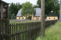
- Hunter's House

Jägerhaus plateau at 782 meters
Former forester's house

Wettinstein from 1889 on Sosaer Strasse

Explanation of the Wettinstein
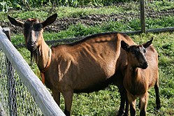
Erzgebirge goat with fawn at the forester's house

_-_fr%C3%BCheres_Forsthaus.jpg)
_-_Wettinstein.JPG)
_-_Wettinstein_-_Erl%C3%A4uterung.JPG)

literature
- Siegfried Sieber : About Aue, Schwarzenberg and Johanngeorgenstadt (= values of our homeland . Volume 20). 1st edition. Akademie Verlag, Berlin 1972, p. 114f.
Web links
- "Das Jaegerhaus" in sheet 222 of the Berlin copy of the Meilen Blätter von Sachsen by Friedrich Ludwig Aster from 1791 ( link to the map in the Dresden State and University Library )
Individual evidence
- ↑ Small-scale municipality sheet for Schwarzenberg / Erzgeb., City. (PDF; 0.69 MB) State Statistical Office of the Free State of Saxony , September 2014, accessed on January 31, 2015 .
- ↑ Geographisch-Kartographisches Institut Meyer (Ed., Head Adolf Hanle): Erzgebirge , in: Meyers Naturführer, Meyers Lexikonverlag Mannheim, Leipzig, Vienna, Zurich 1992, ISBN 3-411-07151-6 , p. 10
- ^ Carl Friedrich Naumann , Bernhard von Cotta : Explanations of the geognostic chart of the Kingdom of Saxony , Arnoldische Buchhandlung, Dresden and Leipzig 1836, p. 125 digitized
- ↑ Natural space map service of the Landschaftsforschungszentrum eV Dresden ( information )
- ↑ Council of the municipality of Bockau (ed.): FDGB -Urlauberort Bockau / Erzgeb. - Hiking guide for Bockau / Erzgeb. und Umgebung , Bockau o. J. (probably 1964), p. 24
- ↑ a b Website of the city of Eibenstock , accessed on March 29, 2016
- ↑ a b To Aue, Schwarzenberg and Johanngeorgenstadt (= values of our homeland . Volume 20). 1st edition. Akademie Verlag, Berlin 1972, p. 115.
- ↑ a b Adolph Lobegott Peck . Historical and geographical description of the Electorate of Saxony. History and description of the Schwarzenberg district office , Schneeberg 1795, p. 122 ( digitized version )
- ↑ Christian Gottlob Wabst: Historical news from the Chur Fürstenthums Sachsen… , Caspar Fritsche Verlag, Leipzig 1732, Beylage page 90 ( digitized in the Dresden State and University Library , see also link to digitized )
- ↑ Walter Fröbe : A millennium of Erzgebirge history. Local history in pictures , 2nd edition, Verlag Wolfgang Weidlich, Frankfurt am Main 1965, p. 102
- ^ New alphabetical index of places of the Kingdom of Saxony. Compiled from official reports by the Central Comité of the statistical association for the Kingdom of Saxony , with the most gracious privilege, Verlag der Waltherschen Hofbuchhandlung, Erste Abtheilung A.–L., Dresden 1836, p. 136 ( link to the digitized version )
- ↑ Pastor Heinrich von der Trenck: The Parochie Bockau in: Georg Buchwald (Hrsg.): New Saxon Church Gallery. Ephorie Schneeberg . Leipzig 1902, Sp. 266 ( digitized version of the original in the Dresden University Library )
- ↑ Topographic map, scale 1.25.000, sheet M 33-50-Ad-Aue-, edition 1991, status 1988, Landesvermessungsamt Sachsen, Dresden 1991
- ↑ StBA: Changes in the municipalities in Germany, see 1999
- ↑ Report on December 1, 2015 in the Freie Presse, regional edition Schwarzenberg ( report on Freiepresse.de ), accessed on November 4, 2018
- ↑ Topographic map 1: 25,000, edition with hiking trails, sheet 15 Westerzgebirge Eibenstock, Johanngeorgenstadt, Sächsischer Staatsbetrieb Geobasisinformation und Vermessung, 2nd edition, Dresden 2010, ISBN 978-3-86170-717-2
Berms green | Crandorf | Erla | Grünstädtel | Heather | Hofgarten | Hunter's House | New World | Pöhla | Sachsenfeld | Schwarzenberg | Sonnenleithe | Wildenau