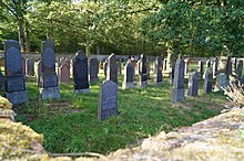
Großkrotzenburg Jewish cemetery
The Jewish cemetery Großkrotzenburg was the cemetery for the inhabitants of the Jewish faith in Großkrotzenburg in the Main-Kinzig district in Hesse . It was laid out around 1700 and was used until 1946.
Geographical location
The Jewish cemetery Großkrotzenburg is located north-northwest and outside the village on the edge of the Schifflache . It can be reached via Waitzweg or L 3308 (turn left at the edge of the forest).
history
The oldest gravestone shows the year 5479 (= 1719). There are possibly older tombstones, the inscription of which can no longer be deciphered, which is why the establishment of the cemetery is assumed to be around 1700. The community had its own synagogue since 1826.
The cemetery was desecrated in 1938. In May 1939, the cemetery was closed for burials, and the congregation was then to bury their dead in the cemetery in Langenselbold . Nevertheless, the last burials took place in 1941 and 1946.
investment
The cemetery has an area of 2177 m². It is surrounded by a quarry stone wall, the entrance is on the northeast corner. About 150 tombstones have been preserved, the majority and the older ones made of sandstone. Younger marble stones often have bilingual inscriptions. A key for the system is kept in the Großkrotzenburg town hall.
literature
- Paul Arnsberg : The Jewish communities in Hesse. Beginning - fall - new beginning. Volume I. Published by the State Association of Jewish Communities in Hesse, Societäts-Verlag, Frankfurt 1972, ISBN 3-7973-0213-4 , pp. 290-292.
- Abraham Frank, Heinz Klab, Monika Ilona Pfeifer: Your soul is integrated into the bundle of life. The Jewish community and the Jewish cemetery in Großkrotzenburg. Ed .: Working group 'Former Synagogue Großkrotzenburg', CoCon, Hanau 2002, ISBN 978-3-928100-70-0 .
Web links
Individual evidence
- ↑ Arnsberg 1972, p. 292.
Coordinates: 50 ° 5 ′ 37.3 ″ N , 8 ° 59 ′ 24 ″ E


