
Jaworki
| Jaworki | |||
|---|---|---|---|

|
|
||
| Basic data | |||
| State : | Poland | ||
| Voivodeship : | Lesser Poland | ||
| Powiat : | Nowotarski | ||
| Gmina : | Szczawnica | ||
| Area : | 34.3 km² | ||
| Geographic location : | 49 ° 25 ' N , 20 ° 33' E | ||
| Height : | 560-590 m npm | ||
| Residents : | 560 (2010) | ||
| Postal code : | 34-460 | ||
| Telephone code : | (+48) 18 | ||
| License plate : | KNT | ||


Jaworki ( Ukrainian Явірки , Jawirky ) is a village with a Schulzenamt of the Szczawnica municipality in the powiat Nowotarski of the Lesser Poland Voivodeship in Poland .
geography
The place is located on the streams Grajcarka (formerly Ruski Potok ), Biała Woda and Czarna Woda, between the Beskid Beskydy ( Beskid Sądecki ) in the north and the Pieninen , specifically the Little Pieninen , in the south, in the west lies Szlachtowa . In the south the place borders on Slovakia.
Other districts are Zapustek and the two former villages Biała Woda and Czarna Woda .
history
The place is located in the so-called Lemkenland , in an enclave furthest west on the Polish side of the border, although it bordered the Russian / Lemk villages Veký Lipník and Stráňany in the south . The first Lemk village in the east of Poland was Wierchomla Wielka . This enclave, called Ruś Szlachtowska by Roman Reinfuss , comprised four villages (Jaworki, Szlachtowa, Biała Woda and Czarna Woda). Until the Vistula Action in 1947, it was inhabited by specific sub-groups of the Lemken .
The place was first mentioned in 1581, under the Ruthenian form of the name (derived from the mountain maples ). Biała Woda and Czarna Woda were created later. In 1651 9 families lived in Biała Woda. In 1680 a Greek Catholic parish was established in Jaworki for the four villages.
During the first partition of Poland in 1772, Jaworki became part of the new Kingdom of Galicia and Lodomeria of the Habsburg Empire (from 1804).
In 1900 the parishes of Jaworki, Biała Woda and Czarna Woda had 156, 122 and 67 houses with 699, 670 and 357 inhabitants, respectively, of which with one exception (a Roman Catholic Pole) all were Ruthenian-speaking and Greek-Catholic.
In 1918, after the end of the First World War and the collapse of the Austro-Hungarian monarchy, Jaworki came to the Second Polish Republic . During the Second World War it belonged to the Generalgouvernement .
After the Vistula campaign, many buildings in Biała and Czarna Woda fell into disrepair or were destroyed. From 1962 to 2007 Jaworki, Biała Woda and Czarna were incorporated into Szczawnica. Biała Woda and Czarna Woda are now just districts of Jaworki.
From 1975 to 1998 Jaworki was part of the Nowy Sącz Voivodeship .
Attractions
- Former Greek Catholic Church, built in 1798, after the Vistula action, Roman Catholic
- Nature reserves: Wąwóz Homole, Zaskalskie-Bodnarówka, Biała Woda, Wysokie Skałki

Former Greek Catholic Church
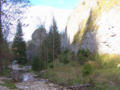
Wąwóz Homole Nature Reserve
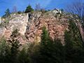
Czerwona Skała (Red Rock) in the Zaskalskie-Bodnarówka Nature Reserve

Biała Woda Nature Reserve


_a1.jpg)

Web links
Individual evidence
- ↑ a b c d Józef Nyka: Pieniny. Przewodnik . Latchorzew 2010, ISBN 978-83-60078-09-9 , pp. 45-46, 69-71 (Polish).
- ↑ Ludwig Patryn (Ed.): Community encyclopedia of the kingdoms and countries represented in the Reichsrat, edited on the basis of the results of the census of December 31, 1900, XII. Galicia . Vienna 1907.