
Josefstädter Strasse
| Josefstädter Strasse | |
|---|---|
|
|
|
 |
|
| Josefstädter Straße at the Theater in der Josefstadt (center) | |
| Basic data | |
| place | Vienna |
| District | Josefstadt |
| Created | before 1683 |
| Hist. Names | Burggasse, Burgtorstraße, Obere Burgtorgasse, Kaiserstraße |
| Name received | 1862 |
| Connecting roads | East: Stadiongasse |
| Cross streets | Lenaugasse, Buchfeldgasse, Lange Gasse, Piaristengasse, Lederergasse, Strozzigasse, Fuhrmannsgasse, Schönborngasse, Kupkagasse, Lerchengasse, Tigergasse, Albertgasse, Bennogasse, Stolzenthalergasse, Blindengasse |
| Places | Josef-Matthias-Hauer-Platz |
| Subway stations | City Hall ( U2 ), Josefstädter Straße ( U6 ) |
| use | |
| User groups | Pedestrian traffic , bicycle traffic , motor vehicle traffic , tram lines 2, 5, 33 |
| Technical specifications | |
| Street length | approx. 1,190 m |
The Josefstädterstraße in the 8th district of Vienna Josefstadt connects the two lines with the belt .
history

Until the end of the 17th century, today's Josefstädter Straße was a roadway over largely undeveloped area. Only after 1683 did an initially isolated construction begin. From 1690 to 1778 it was referred to as Burggasse or Burgtorstraße, outside of Piaristengasse Obere Burgtorgasse, and from 1778 to 1862 Kaisergasse. It formed the border between the suburbs of Josefstadt , Sankt Ulrich , Strozzigrund and Altlerchenfeld until they were incorporated into Vienna in 1850. Eventually it was named Josefstädter Straße after the suburb of the same name.
Until 1892 Josefstädter Straße ended at Blindengasse; the breakthrough to the Lerchenfelder Gürtel could only take place after the line wall and the institute for the blind in Blindengasse were torn down.
In 1788, the theater in der Josefstadt was built on plot No. 26 (the current building dates from 1822).
From 1772 to 1903 the Josefstädter Kaserne (kk Kavalleriekaserne) was located at Josefstädter Straße 46-64 . After its abandonment, it was demolished in the course of the barracks transaction from 1903 to 1910.
On December 11, 1887, a horse-drawn tram line was opened through Josefstädter Strasse, which initially ended at Blindengasse and was extended to the Gürtel in June 1898. Electrical operation began as early as January 28, 1897 in the section between Albertgasse and Blindengasse, and on September 25, 1901 also on the section in the other parts of the street.
description
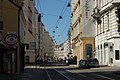
Josefstädter Strasse begins at Auerspergstrasse / Landesgerichtsstrasse as an extension of Stadiongasse; it is slightly curved and gently ascending to Piaristengasse in an approximately west-northwest direction.
The road is closed; the majority of the buildings date from the time of Viennese historicism with a few buildings from earlier periods. Right at the beginning there is the Café Eiles on the right (No. 2). One block further on was the management of the municipal gas works (today a hotel, but still recognizable by two mounted gas lamps) at numbers 10–12. On the corner of Lange Gasse there is an ensemble of three houses from the Baroque and Biedermeier periods on the left (no. 15, 17 and 19). At the end of the same block on the right is the theater in der Josefstadt (no. 24–26). The historicist street wing follows on the left at No. 39, behind which the baroque Strozzi Palace is hidden. Café Hummel is established on the corner of Albertgasse and Josef-Matthias-Hauer-Platz . Finally the street ends with house numbers 82 and 105 at Lerchenfelder Gürtel .
Josefstädter Straße is a shopping street with a large number of mainly small shops from various industries as well as gastronomic businesses.
Josefstädter Strasse is poor in terms of green spaces. Only at the beginning is there a small horticultural area in Auerspergstrasse. Another green area is located on Josef-Matthias-Hauer-Platz.
traffic
Josefstädter Straße is a local connection from the city center to the 8th district and the Gürtel. It has no direct extension there; the Neulerchenfelder Straße begins on the other side of the belt about 50 meters to the south. The tram is therefore swiveled under the viaduct of the U6 subway line in this direction, while private transport is guided like a roundabout.
The street is classified as main street A. It is passable in both directions.
The street is not wide enough to provide facilities for individual groups of users, so that vehicles, cyclists and trams have to share the driving space.
The tram opens up Josefstädter Strasse over its entire length. Since the system of line signals was introduced in 1907, this has been Line J for over a hundred years; Since October 2008 it has been carrying line signal 2. In addition, line 5 between Albertgasse and Blindengasse and line 33 (until May 1996: 31/5) along Josefstädter Straße from Albertgasse to Gürtel. Josefstädter Straße is crossed by bus line 13A (towards Alser Straße : Piaristengasse; towards Hauptbahnhof [until autumn 2020 due to the redesign of Neubaugasse diverted to Volkstheater ]: Strozzigasse).
There is access to the subway in Landesgerichtsstraße ( Rathaus subway station , line U2 ) and on the Gürtel ( Josefstädter Straße subway station , U6 line).
Notable addresses
(Listed objects are highlighted in bold.)
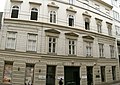
- No. 2 Café Eiles , located in a house from the late Biedermeier period , from 1846 to 1850 Friedrich Hebbel's house
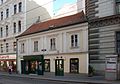
- No. 11 To the green snake, To the beautiful shepherdess - late Biedermeier dwelling
- Nr. 15 Gasthaus zur golden bowl - town house from the time around 1700, changed in the second half of the 18th century (address: Lange Gasse 33)
- No. 17 To the four molds - residential and commercial building with an early historical facade; 1874 Gottfried Keller's house , where Karl von Frisch was born
- No. 19 Zum Blumenstock - rental house from 1789, redesigned in 1836
- No. 21 Gustav Klimt's former studio
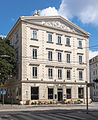
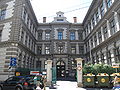
- No. 24–26 Theater in der Josefstadt
- No. 32 Classicist house (1788–1790)
- No. 37 Biedermeier house (1772)
- No. 39 Strozzi Palace
- No. 66 Café Hummel ; The previous building of the rental house built in 1895 was the home and death house of the composer Philipp Fahrbach the Elder
- No. 76 House with facade decoration in the style of the Wiener Werkstätte
- No. 80 Headquarters of the Insurance Company for Public Employees, Railways and Mining
- No. 93–97 Residential building from 1963 with three listed concrete reliefs on the facade
Picture gallery
No. 2, Café Eiles

No. 11

No. 15 (ident: Lange Gasse 33)

No. 17
No. 19

No. 21, secessionist house

No. 24–26, Theater in der Josefstadt

At Piaristengasse, line of sight to St. Stephen's Cathedral

No. 32
View from Strozzigasse out of town
No. 37

No. 38 (at the corner of Lederergasse), late historic house
No. 39, street wing of the Strozzi Palace
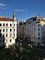
At Albertgasse

No. 76

No. 93–97, facade decorations


Web links
Plan view of Josefstädter Straße in OpenStreetMap
Individual evidence
- ↑ a b c Josefstädter Strasse. In: Vienna History Wiki. City of Vienna, accessed on March 27, 2020 .
- ↑ a b c Federal Monuments Office (ed.): Dehio manual. The art monuments of Austria. Vienna II. To IX. and XX. District Verlag Anton Schroll & Co ISBN 3-7031-0680-8 (short: Dehio ) p. 351
- ^ Dehio p. 341
- ↑ Josefstadt barracks. In: Vienna History Wiki. City of Vienna, accessed on March 28, 2020 .
- ↑ Route openings . In: Tram Journal Wiki. Retrieved March 27, 2020 .
- ↑ All lines. In: Tram Journal Wiki. Retrieved March 27, 2020 . (with links to individual lines)