Jug (river)
|
Jug Юг |
||
|
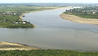
The Yug (left) unites with the Suchona (above) near Veliki Ustyug (above right) to form the Northern Dvina |
||
| Data | ||
| Water code | RU : 03020100212103000009969 | |
| location | Kirov Oblast , Vologda Oblast ( Russia ) | |
| River system | Northern Dvina | |
| Drain over | Northern Dvina → White Sea | |
| source | on the northern Russian ridge , 40 km northeast. from Nikolsk 59 ° 46 ′ 8 ″ N , 46 ° 3 ′ 54 ″ E |
|
| Association with |
Suchona to the Northern Dvina Coordinates: 60 ° 43 ′ 54 " N , 46 ° 19 ′ 54" E 60 ° 43 ′ 54 " N , 46 ° 19 ′ 54" E
|
|
| length | 574 km | |
| Catchment area | 35,600 km² | |
| Discharge at the Permas A Eo gauge : 1450 km² Location: 414 km above the mouth |
MNQ 1959/1988 MQ 1959/1988 Mq 1959/1988 MHQ 1959/1988 |
2.2 m³ / s 12.6 m³ / s 8.7 l / (s km²) 56.8 m³ / s |
| Discharge at the Kitschmengski Gorodok A Eo gauge : 8,890 km² Location: 244 km above the mouth |
MNQ 1957/1988 MQ 1957/1988 Mq 1957/1988 MHQ 1957/1988 |
17 m³ / s 73 m³ / s 8.2 l / (s km²) 301 m³ / s |
| Discharge at the Podossinowez A Eo gauge : 15,200 km² Location: 119 km above the mouth |
MNQ 1930/1999 MQ 1930/1999 Mq 1930/1999 MHQ 1930/1999 |
28 m³ / s 119 m³ / s 7.8 l / (s km²) 480 m³ / s |
| Discharge at the Gavrino A Eo gauge : 34,800 km² Location: 35 km above the mouth |
MNQ 1936/1988 MQ 1936/1988 Mq 1936/1988 MHQ 1936/1988 |
61 m³ / s 290 m³ / s 8.3 l / (s km²) 1380 m³ / s |
| Left tributaries | Sharschenga , Kitschmenga | |
| Right tributaries | Lusa , Puschma , Jontala | |
| Small towns | Podosinovets , Demyanowo | |
| Communities | Kitschmengski Gorodok , Kurilowo , Kusino | |
|
The Jug (Юг) forms the right source river of the Northern Dvina in the south of its catchment area |
||
The Jug ( Russian Юг ; German literally "south", but etymologically probably has nothing to do with the compass direction) is a 574 km long river in the European part of northwestern Russia .
It rises on the elongated north Russian ridge about 40 km northeast of Nikolsk and flows from there first a piece in a south-westerly direction. Then it meanders mostly in deeply cut valleys, mainly in a northerly direction as far as Veliki Ustyug , in order to unite there with the Sukhona coming from the west to form the Northern Dvina .
Larger tributaries are Sharschenga and Kitschmenga from the left, and Lusa , Puschma and Jontala from the right.
Web links
Individual evidence
- ↑ a b Article Jug in the Great Soviet Encyclopedia (BSE) , 3rd edition 1969–1978 (Russian)
- ↑ a b Jug in the State Water Register of the Russian Federation (Russian)
- ↑ Jug at the Permas gauge - hydrographic data at R-ArcticNET
- ↑ Youth at the Kitschmengski Gorodok gauge - hydrographic data at R-ArcticNET
- ↑ Youth at the Podossinowez gauge - hydrographic data at R-ArcticNET
- ↑ Jug at the level Gavrino - hydrographic data for R-ArcticNet

